NavList:
A Community Devoted to the Preservation and Practice of Celestial Navigation and Other Methods of Traditional Wayfinding
From: Frank Reed
Date: 2020 Sep 28, 12:18 -0700
Greg,
You wrote:
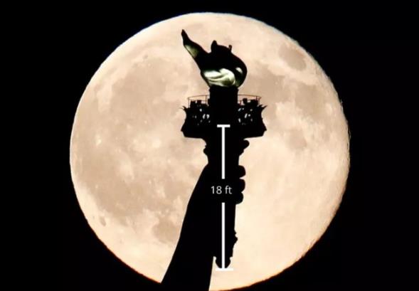
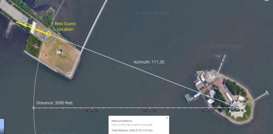
"Attached is another blue moon image taken at the same time by the same photographer Julio Cortez. See plot from liberty park through the statue of liberty onto JFK to confirm moon azimuth at around 110°."
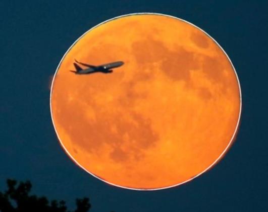
My reading of Don's post was that he found the aircraft's implied altitude unlikely, and he was suggesting that it was a plane that was passing near JFK along the line of sight that might have taken off from somewhere else, e.g. LaGuardia, not that the photographer was looking towards LaGuardia. Based on a better estimate of the photographer's location (see below), I think it all probably makes sense now and that aircraft is climbing out at a steep angle over Jamaica Bay heading southwest, which is normal for flights out of Idlewild.
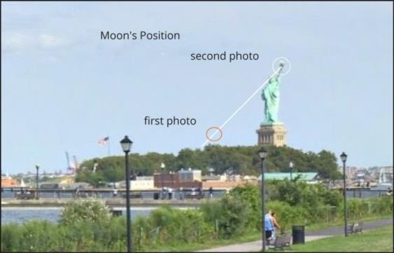
Setting that aside, this fantastic second photograph that you found, Greg, showing the torch of the Statue of Liberty in front of the Moon, which I estimate was taken 12-17 minutes after the first with the airplane in front of the Moon, really nails down the details on both photos. We know the size of the torch (within some margin of error). We know the angular size of the Moon for scale, so that gives us a reasonable estimate of distance off --about 3500 feet. Given that distance, and given that a photographer has to set up on safe, solid ground, we can determine that he was very likely located on "Black Tom Island" in "Flag Park", easy to get to and great for Statue of Liberty and Lower Manhattan skyline photography. I think I have pinned down the location within about ten feet on a direction perpendicular to the line of sight to the statue and within maybe fifty feet in the perpendicular direction (the "distance off" direction). Further, we can track the Moon back lower in the sky and see that those foreground trees, which I had assumed were near the photographer, are, in fact, on Liberty Island close to the statue.
With all of these details in hand, we can figure out with some greater certainty what the aircraft's position was in three dimensions. Anyone?
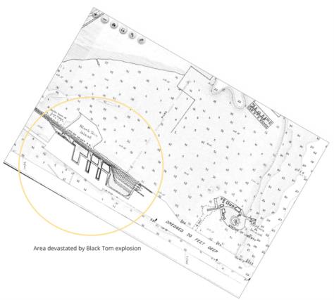
For some history, the photographer's probable location has an indirect connection to the accessibility of the Statue of Liberty and also to Beirut. Black Tom Island and the pier that connected it to the New Jersey mainland was the site of one of the largest non-nuclear explosions in history and one of the most successful acts of sabotage ever on US territory. On July 30, 1916, ninety-nine years and a day before these Moon photos were taken, a German saboteur set off a bomb that denoted a massive cache of weapons bound for the war in Europe. There were few deaths since the port was not active in the middle of the night, but there was enormous damage to the port facilities, and comparisons have been made to the recent port explosion in Beirut. Windows were blown out across Jersey City and in lower Manhattan, and the arm of the Statue of Liberty suffered some damage which led to the closing of the arm and the torch which was previously accessible to daring tourists. The arm and torch have been inaccessible ever since.
Frank Reed
