NavList:
A Community Devoted to the Preservation and Practice of Celestial Navigation and Other Methods of Traditional Wayfinding
From: Frank Reed
Date: 2023 Sep 3, 06:18 -0700
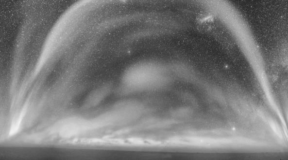
Here's a photo taken at high southern latitude. How many official navigation stars can you identify? The field of view is wide. I estimate it's on the order of 180° by 90°. That's approximately one-quarter of the celestial sphere. Since there are 57+1 official navigation stars, and since they have been chosen to be evenly-spaced around the sphere, you should be able to identify a dozen or more nav stars, even with considerable interference from the glowing aurorae in the photo. That wide field implies a rather complex mapping from pixels (points in the image) to altitude and azimuth, but even so, can you figure out approximately where the photo was taken? It doesn't have to be exact. Can you make a convincing case from the altitudes of the stars?
I'm trying to keep this one strictly astronomical, a case for celestial navigation analysis. So if you determine the location by some other means, like using Google to find the image or recognizing it from some other source, please don't invoke that in your analysis. Of course, I can't ask you to un-know whatever you might discover by other means. But please try not to bring it up in your analysis.
For my fellow northern-hemisphereans: look for Sirius and the constellation Canis Major, but don't forget that the constellations tend to be upside-down in southern skies compared to the familiar patterns we see in mid to high northern latitudes.
Frank Reed


