NavList:
A Community Devoted to the Preservation and Practice of Celestial Navigation and Other Methods of Traditional Wayfinding
From: Don Seltzer
Date: 2014 Oct 25, 19:27 -0400
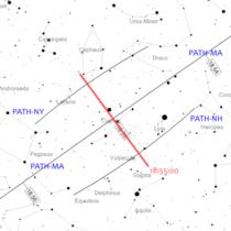
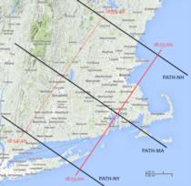
The attached star chart and ground map for tomorrow evening's ISS pass should provide a sense of scale on the navigational solution here. With simple naked eye observations, it's possible to lay down a line of position parallel to the centerline with an accuracy of about five nautical miles. And if the observation can be timed to the nearest second, then the position along that line would also be accurate to about five miles. The speed of advance is the same as the ground track speed. The ISS (and any LEO satellites) completes an orbit in 90 minutes, so the red line on the ground map is advancing at a speed of just about 14,400 knots which is exactly 4 nautical miles per second. With binoculars, we can refine the location of the line of position relative to the center line by a factor of ten relatively easily, but the timing probably cannot be improved much.
-FER
Attached File:
(ISS-in-sky-oct-25.png: Open and save)
Attached File:
(ISS-ground-oct-25.png: Open and save)


