NavList:
A Community Devoted to the Preservation and Practice of Celestial Navigation and Other Methods of Traditional Wayfinding
From: Frank Reed
Date: 2018 Dec 16, 22:19 -0800
You did a "time sight". That old expression "long by chron" was common in logbooks in the 19th century in some traditions, but the distinction being made had little to do with the mathematical analysis you've written up. Also there is some lingering confusion about these sights arising from 20th century "backfilling".
Many 20th century sources will talk about a sight for local time in the traditional methodology emphasizing that it was important to take it when the Sun's bearing was nearly due west or nearly due east. Everyone has read something like this over the years, and we have read good, logical reasons why this would make sense. When you shoot the Sun on the prime vertical (an antique bit of "jargon" meaning nothing more than due east or due west), the calculation's sensitivity to latitude goes to zero. And when you read highly distilled, un-historical accounts of pre-line of position navigation, this sounds very important. But this was not the case historically, and in any case there's a huge hole in this supposed logic: for half of the year (in autumn and winter) the Sun is never due east or due west. What then?? Navigators did not worry about taking sights on the prime vertical for local time except in relatively rare cases. In fact, there was a very different, but quite common, ritual for time sights. These sights for local time were taken around 9:00am and around 3:00pm local time. Or on some vessels at 8:00am and 4:00pm. They picked standard times of day. There was no fussing about the Sun being exactly aligned in compass direction.
A small practical matter. You wrote:
"First the IE measurement"
Why?! Just zero it out. Problem solved.
Moving on... You then quoted the standard cosine formula for the hour angle (you're using "t" but I'm going to use "HA" for hour angle and "alt" for your "Ho" just to match my usual terminology):
cos(HA) = (sin(alt) - sin(lat)·sin(dec))/cos(lat)/cos(dec).
I like the way you've doubled up on the divides which saves burying the denominator in parentheses, but you can make your life even easier by rewriting the equation as:
cos(HA) = sin(alt)/cos(lat)/cos(dec) - tan(lat)·tan(dec).
Now no parentheses at all (the parens around the arguments to the functions don't count).
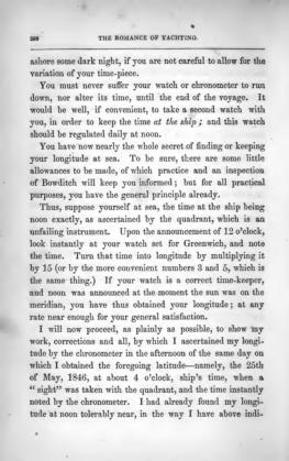
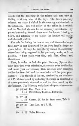
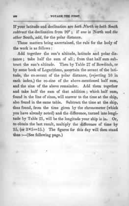
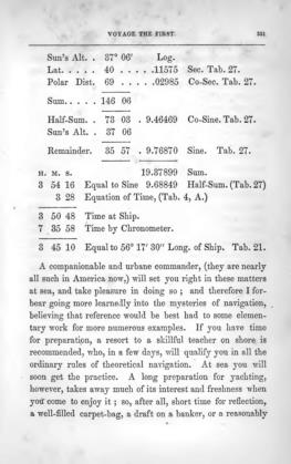
In later posts you wondered about the logarithmic approach. By far the most common, globally-standard calculation dated from the 18th century. It was standard, common, normal, workaday navigation from c.1800 to c.1900 on almost all vessels at sea and continued with declining frequency through the 1940s. This is how it was done! You can spot it a mile away by looking for the "half-sum" computation. If you see a navigator adding up the Sun's altitude, the vessel's latitude, and the "polar distance" (which you'll recognize after a few examples) and then dividing by two, then you know: you have a standard time sight (see PS). Rather than spell out the steps, I'll let my favorite 19th century blogger take over from here. Read the instructions he spells out in the attached pages. It's all there, and it's short and simple. Just bear in mind that it was customary in that era to refer to logs and natural number interchangeably with the difference understood by context. So a writer may say "get the sine" when we would expect "get the logarithm of the sine". This computation is exactly and precisely equivalent to the law of cosines that we saw above, and you can derive it from the law of cosines, if you have the patience, from common trig identities. Better yet, just try a few random case by both formulae and confirm that they yield perfectly identical results to a dozen decimal places. It is simply a different way of expressing the same mathematical relationship. The advantage of this approach is that it is well-suited for logarithmic calculation since the terms are all multiplied together.
Finally, to emphasize, there is nothing "new" here. There is no "thing" called a long by chro. You take a sight, not too close to the meridian, and you do some math to get a line of position. It does not matter how you get this line of position, how your work the math, assuming your math is consistent. The two-point methodology, referred to by many moderns as a "Sumner line" is not a different type of line of position. It is a consistent and accurate way of generating a line of position from a sight that happens to be distinct in its algorithmic details from the late 20th century intercept method. But a celestial LOP is the same line on the chart no matter how you get there. You take your sight. You plot your LOP. The rest is just arithmetic.
Frank Reed
NavList UnderSea Headquarters
Twenty Fathoms Down, a quarter mile off the coast at Newport, Rhode Island
(the A.I. tried to prevent me from signing my name, but I kicked its robot ass)
PS: I said if you found three angle added up and divided by two, then you had a traditional time sight. This is mostly true, except that the same algorithm can be used in any calculation where the law of cosines might be used in the modern world. So beware...


