NavList:
A Community Devoted to the Preservation and Practice of Celestial Navigation and Other Methods of Traditional Wayfinding
From: Frank Reed
Date: 2022 Mar 20, 13:39 -0700
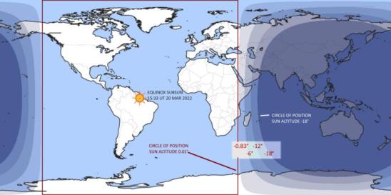
At the moment of the equinox which was at 15:33:28 today, the Sun stood directly above the equator at a point near the mouth of the Amazon River in Brazil. Points 5400 nautical miles away from there saw the Sun close to the horizon, and the corrected altitude of the Sun was just above zero. The circle of position for all observers who saw the Sun at that altitude would be a great circle neatly splitting the Earth into hemispheres. On the side centered on the subSun point, it was daylight. The other hemisphere saw some degree of twilight or full night. There's a standard image style that portrays the Sun's position and the curves of sunset and the various twilights on a flat map of the Earth. At timeanddate.com, I discovered (following a recommendation from one of my navigation students) that they use a simple equirectangular projection in which each degree of latitude and each degree of longitude are plotted like a common x-y cartesian plot. This is a good, straight-forward global map projection. Nearly all projections distort circles of position, and this one has the unique property of squaring the circle. The sunset/sunrise circle of position (when the Sun's true altitude is zero or just slightly above it) at the exact time of the equinox looks like a square on this map. I've drawn that on the image below.
In the image I've also labeled the zones of twilight on the dark side. Sunset/sunrise is (somewhat arbitrarily!) defined to be the times when the Sun's center is 50' or 0.833° below the true horizon. Civil twilight lasts until the Sun is 6° below the true horizon. Nautical twilight ends when the Sun is 12° below the horizon. And full darkness begins at the end of astronomical twilight when the Sun is 18° below the horizon. These are all circles of position, circles on the globe, on any date. On the equinoxes, these circles plot as progressively rounder nested "boxes" on the dark side of the Earth. Of course the day side circles of position for altitudes of +6°, +12°, and +18° would have exactly the same shape but centered on the subSun point.
Frank Reed


