NavList:
A Community Devoted to the Preservation and Practice of Celestial Navigation and Other Methods of Traditional Wayfinding
From: David Pike
Date: 2023 Mar 11, 03:40 -0800
Andrés
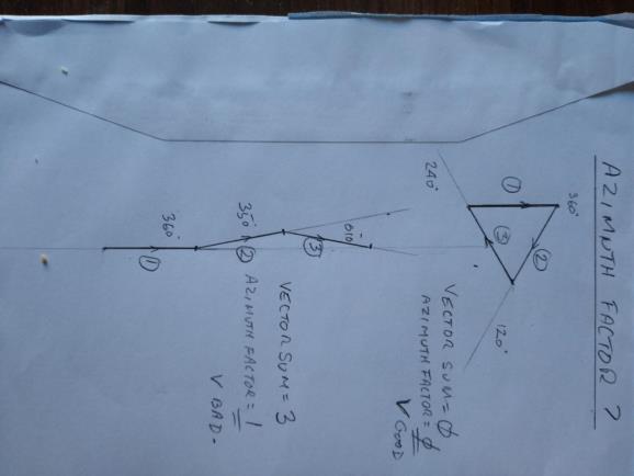
I kind of gave up on higher maths about the time I found out about beer and girls, but are you saying three azimuths 360, 120, 240, value unity, added vectorially = zero. Zero/3 = zero = Perfection?
Three azimuths 360, 350, 010, value unity, added vectorially = almost 3. Almost 3/3=almost unity = rubbish = exercise failed on seamanship. See diagram. Sorry about the crumbs; it was coffee time.
This bears out what I was saying. In chart, protractor, divider, and periscopic sextant navigation using Betelgeuse, Bellatrix, and Rigel to produce a fix is not the best use of all the stars in the sky, and this would be immediately obvious when you tried to plot it. Putting the same sights into a computer, beware GIGO. You’ll always get a solution, but how much reliance can be put on it.?
On the 2D 3D idea, I was wondering if the clever people at the USN laboratories could modify the mathematics within a GNSS receiver to give a solution for submarine celestial if viewing was limited to a small portion of the sky as often happens on the surface. E.g., you suddenly catch a glimpse of Orion though a gap in the clouds as frequently happens. However, after 30 minutes thought, you realise it would be a big jump. GNSS is range spheres and receiver clock correction, whereas intercept method celestial is intercepts and azimuths. Moreover, even GNSS receivers are particular over which satellites they choses to use from the several available to them at any one time. It's a lovely sunny day here, so I really brave the cold and get on with renovating the equipment from 17ft Doranne, which at the moment seems to be demanding just as much time as 27ft TIKI did. DaveP


