NavList:
A Community Devoted to the Preservation and Practice of Celestial Navigation and Other Methods of Traditional Wayfinding
Re: Sun even nearer zenith
From: Lu Abel
Date: 2016 Sep 27, 19:43 +0000
When asked about the most important upgrade he made to his boat between the first and second race, unhesitatingly replied "an active AIS system" (for those unfamiliar, this is a system that broadcasts your position and identification via VHF, thereby alerting other nearby AIS-equipped vessels to your presence). "The standard of watchkeeping on ships offshore has become so poor that they simply no longer keep a visual watch and only pay attention to their radars when it gives a 'nearby reflection' alarm; they rely almost entirely on AIS to warn them of nearby vessels, so God help you if you're a single hander in a fiberglass boat and don't have AIS."
From: Lu Abel
Date: 2016 Sep 27, 19:43 +0000
Re radar: At a US Power Squadrons regional meeting last year we had as a speaker a gentleman who had participated in the single-handed race from San Francisco to Hawaii, once about a decade ago and then again just a couple of years ago.
From: Rommel John Miller <NoReply_Miller@navlist.net>
To: luabel@ymail.com
Sent: Tuesday, September 27, 2016 12:13 PM
Subject: [NavList] Re: Sun even nearer zenith
That I think, is one of the newer USN littoral craft. Virtually invisible by design to be detect radar wise. However, as many sailboats today still have radar, I could see where chance adverse meeting in the night would be disastrous.I would hope that since the Navy has far advanced radar they would see my tiny little West Sail floating in the middle of the ocean in the middle of the night.USS Zumwalt was or is to me commissioned at Ft. McHenry sometime in October to match her launch date and fitting out. http://usszumwalt.org/All the best and can anyone help me obtain #3195 a 42' Westsail Center cockpit at cbmm.org the Chesapeake Bay Maritime Museum in St. Michael's MD.Rommel John Miller8679 Island Pointe DriveHebron, MD 21830410-219-2690On Fri, Sep 23, 2016 at 9:53 PM, Frank Reed <NoReply_FrankReed@navlist.net> wrote:Stan K, you wrote:
"I'm getting a stiff neck just thinking about these."Ha ha! Yeah, they're up there.While I'm thinking of it, some of you may have noticed that the latitude in Bob's image is displayed as 0° 00.002'. which might seem to imply that he wasn't quite on the equator. But convert that to feet. There's about 6000 feet per minute of arc of latitude (and also longitude for locations in the tropics), so 0.002' measures out to 12 feet. And you notice that the displayed accuracy of the GPS fix, as reported by the chipset within the phone, was also +/- 12 feet. The position is thus consistent with a location exactly on the equator. This would be the geodetic equator on the WGS84 datum. Astronomical latitude, such as we get from an altitude of the Sun, would differ by the amount of the local deflection of the vertical in the north-south direction which could easily amount to a few hundred feet on the ground.Frank Reed
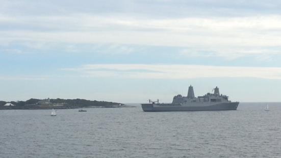
Conanicut Island USAPS: Today's fun with smartphone apps. There was a helluva loud noise south of the island here today.. sounded like a couple of helicopters doing a rescue or something. I looked on the MarineTraffic app and saw that there was no unusual activity except the pilot boat right at the entrance to the bay. To me that spelled "Yvan eht Nioj" because USN vessels don't normally show up on the AIS (sometimes, yes, but not normally) so I hopped in the car and went down to the cliffs. Sure enough, a big amphibious landing ship, which I later determined was the brand new USS John P. Murtha (scheduled for commissioning two weeks from now), was heading slowly out of Narragansett Bay and an Osprey tilt-rotor was landing on her deck, probably to impress some participants in the Seapower conference which was being held in Newport. I stayed long enough to see the Osprey take off and transition to level flight, which was fun. The smartphone also took the photos, of course. Here's one:
Attached File:


