NavList:
A Community Devoted to the Preservation and Practice of Celestial Navigation and Other Methods of Traditional Wayfinding
From: Brian Walton
Date: 2021 Apr 6, 02:49 -0700
1. CV19 means that I have not flown or done astro from a moving boat for 6 months. I am therefore now an armchair pundit.
2. Maskelyne used log versines or haversines, plus log secants and sines to derive a longitude from lat, dec and Ho. This method (involving about 8 lines of math, plus 5 look ups and additions of 5 figure tables) then called long by chron, together with a noon lat, endured in the mechant marine for over a hundred years. Azimuth could be found by sinAz=cosDec. sin t . sec Ho, but was not needed.
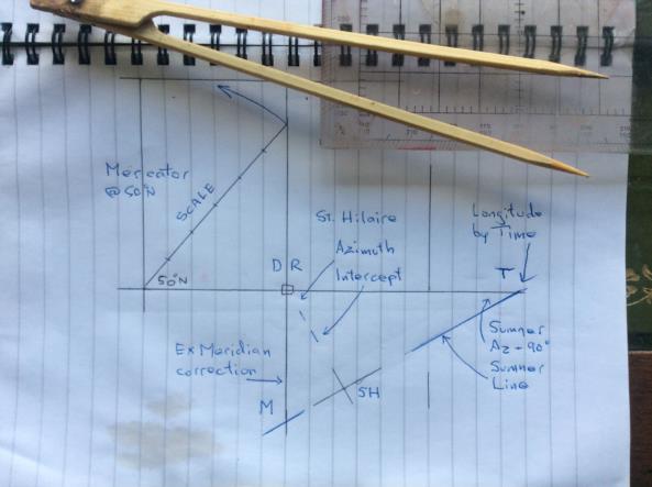
3. The Bygrave cylindrical spiral slide rule uses lat, dec and t with 6 movements, and some math, to find Az and Hc, and thus Zn and intercept. The operator does not need to look up trig logs. I have long wanted to use a Bygrave to work out a time sight by reverse inputs, but failed because of the need to input azimuth as raw data, and that required a separate slide rule to work the formula given in para 2. I then found that given azimuth and intercept by Bygrave, simple plotting gave long by chron, ex- meridian, and Sumner lines, with no extra calculation. See the attached plot, made on an exercise book I use as a deck logbook.
4. A Mercator plot is constructed using the exercise logbook lines. Only the black lines are needed; the blue lines are for explanation. I have chosen 50°N. A scale is formed as shown. 10 miles per line works well for a boat averaging about 6 kts, rather more for an aircraft, but I have chosen 1 mile per line to illustrate the principle.
5. If a Bygrave solution gives a towards intercept of 3 miles, on an azimuth of 150°, it is plotted from DR to SH, and a PL is drawn at 90°; black lines.
6. If the St Hilaire PL is extended to the DR lat, position T gives the longitude by time solution, and is in effect a Sumner line. If the St Hilaire PL is extended to the DR long, position M gives the ex-meridian correction. This can be checked by rearranging Maskelyne's formula.
7. So, by simply extending the St Hilaire PL, one can find Long by Time, Sumner's line, and ex- meridian corrections without any need for logs or trig !! Any other PL from any source can be plotted directly from DR to get a fix, provided the DR is worked correctly, and the azimuth differs by more than about 25°.
Brian Walton


