NavList:
A Community Devoted to the Preservation and Practice of Celestial Navigation and Other Methods of Traditional Wayfinding
From: Frank Reed
Date: 2018 Sep 27, 12:12 -0700
Steve Dunlop, you wrote:
"Recreational vessels rarely make passages lasting longer than 30 days, so the question becomes whether the error in a cheap quartz watch is acceptable after 30 days. With a good quality mechanical watch, you could be off by 150 seconds, with a cheap quartz watch, you could be off by 30 seconds. Maybe that's close enough. I am a novice, but it seems like 30 seconds of avoidable uncertainty is worth thinking about, at least a litte."
I feel that you're setting up scenarios that are too theoretical, too fantastical, and then considering a worst case scenario that's too extreme.
First, if all the GNSS satellites go down, your next stop is the nearest safe harbor because something is very wrong with the world! It's hard to imagine a case where you couldn't get to safe harbor in seven to ten days. The odds of such an extreme event are exceptionally low, of course. Should we even consider this sort of zombie apocalypse type of event? Preparedness is about planning for likely failures. As with any insurance plan, you spend your money and effort in inverse-proportion to the probability of the need for it. The best backup for a GPS is another GPS and then a few more GPS options after that. Unless you're following the open-ocean option of using celestial as a battery-saver, "inverting the logic" as I described yesterday, you're not going to fall back on celestial navigation for position-finding (see PS) as a genuine backup until you're way down the list of failures and possible backups. It's good to have, but it's just not mission-critical (except for licensing and some races where the laws or rules simply decree that you do it).
Second, an error of 30 seconds from a quartz watch in 30 days is extreme and possibly reflects a confusion over the concept of clock error. A good clock, in the definitional sense, is not a clock that reads the correct time; it's a clock that has a fixed and stable rate error so that a user can confidently apply a linearly-calculated correction to the displayed time. 
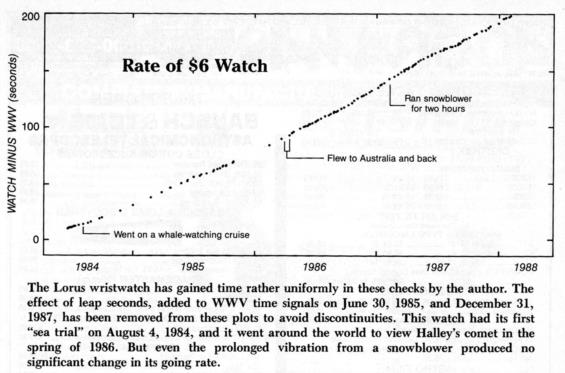
As in Roger Sinnott's case of his experiment thirty years ago (click the image above to enlarge), if a clock reliably gains one second per week, then it's easy to determine the correct time after any number of weeks have elapsed. This ability to rate a clock and then correct it changes the game, and this was understood very well over 200 years ago. We no longer need to hunt for a radically better clock. We only need to make sure that we regularly (once a month?) check the rate on any backup watch if we want to have an armaggedon-proof celestial option.
Finally, there are other ways to check clocks. Look back to history. In the early 19th century, whenever two vessels met at sea, they would trade longitudes (or equivalently Greenwich time). By the early 20th century, it was no longer necessary to be in proximity to another vessel. Just get on the radio and ask. Similarly in the modern world, even if you can't transmit a call for the correct time, just listen to the radio for a time check from a commercial source, perhaps WCBS New York or a BBC World Service station. Yes, it might be off by five to ten seconds, but that's harmless. And you could conceivably manage this once every few days on the high seas and daily, even hourly, within a couple of hundred miles of land. My point here is that WWV is not the end-all technology for getting time by radio. It is a convenience service that saved mariners from calling out "Hey, what time is it?" all day long and filling up the airwaves.
Frank Reed
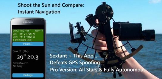
PS: Celestial navigation for position-finding, determining latitude and longitude, is the meat-and-potatoes of traditional celestial navigation. Today in the year 2018, that's a side-dish. As Jeremy has emphasized, the benefit of celestial observations for compass checks is often overlooked. Every tool that provides live data on astronomical objects at sea should always include the live azimuth. My GPS.anti.Spoof app includes that as a standard, main-screen feature, and of course that app points to yet another non-position-finding function for celestial: detecting GPS spoofing. Although the probability of spoofing is near zero in many parts of the world, it is recognized as a real and growing threat in certain theaters of operation. Sextant sights are a cheap and simple check against spoofing (on a scale larger than the typical system acccuracy of celestial which is about a nautical mile). But that will never happen if we fall back on "disco era" celestial, working out everything on paper. Just use an app. Compare your sight with the predicted altitude calculated by an app based on the received GPS position, and you're done in an instant. That's navigation. It may not be as much fun as playing around with paper and pencil, but it solves a real-world navigation problem. ... Advert: get my app!


