NavList:
A Community Devoted to the Preservation and Practice of Celestial Navigation and Other Methods of Traditional Wayfinding
From: Geoff Hitchcox
Date: 2019 Apr 30, 19:32 -0700
Back in the day : 15 March 2012, Paul Hirose wrote:
"I wonder if has anyone has a theory on what stars Mr. Lightoller shot to give Titanic her last fix."
Thanks Paul, that sent me down a very enjoyable rabbit hole !
Because I have no background, history, qualifications or attended any courses in Celestial Navigation, I thought it would be great to start with the Titanic - after all it is unsinkable and what could possibly go wrong !
So the following is my solution for the C.N. "final" fix position.
Paul, you based your DR on the SOS coordinates, I decided to be different and use the Iceberg instead to DR from.
Following are my workings:
Regards, Geoff Hitchcox, Christchurch, NZ
------------------------------------------
Perform a DR from the Iceberg location (which is referenced to actual wreck site of the Titanic by current and drift).
41:45.5' N, 49:55 W Iceberg allision [1]
Using 11:40pm allision time to 7:30pm Celestial Fix (in ATS time) [2].
Distance = 22 knots at 4.17 hours = 91.74 nm [2].
Distance = 91.74 nm = 169.90248 km.
Bearing = 266-180 = 86 degrees [2]
Perform Rhumb Navigation:[3]
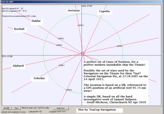
41:51:54" N, 047:52:18" W (Geoff's location for Titanic C.N. fix)
This "new" C.N. fix location is 1.40 nm from Sam Halpern's fix (derived from Boxhall's (Titanic) SOS position which has been "corrected" with the assumed Traverse Table misreading) [2].
------------------------------------------
Assumed local Noon Position of Titanic [2]
14 April 1912
43:02 N , 44:31 W
Sun Transit 14:58 GMT
Moonset 18:40 GMT
Sunset 21:39 GMT
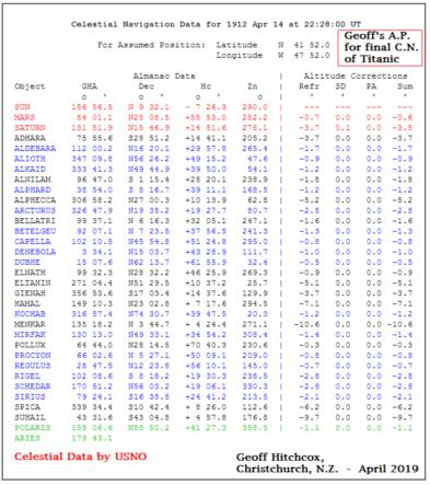
C.N. Data by USNO [4]
Attached graph of LOPS made with Teacup Navigation [5]
- many thanks to Rodger Farley
------------------------------------------
[1] Collision Point by Samuel Halpern, July 2007
https://www.glts.org/articles/halpern/collision_point.html
[2] Mistakes In The Night , By Samuel W. Halpern
www.titanicology.com/Titanica/Mistakes.pdf
[3] Rhumb Calculator:
https://www.movable-type.co.uk/scripts/latlong-nomodule.html
[4] Celestial Navigation Data for Assumed Position and Time
https://aa.usno.navy.mil/data/docs/celnavtable.php
[5] Teacup Navigation - Free Book and Software
https://www.teacupnavigation.net/CN.html
------------------------------------------


