
NavList:
A Community Devoted to the Preservation and Practice of Celestial Navigation and Other Methods of Traditional Wayfinding


From: Paul Dolkas
Date: 2022 Jan 13, 21:33 -0800
Bryan-
Along those same lines, here is an interesting article on a "Coconut Sextant", used by the ancient Hawaiians & Polynesians
as a kind of astrolabe for determining lattitude:
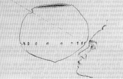
Polynesian Navigating Tohunga often would use a a sextant (titiro etu) made from a coconut shell cut across at a slanting angle with a hole at the low end, and a notch at the top end, and a number of holes encircling it. These sat above a wavy line representing the ocean and underneath an arch of ten stars evenly spaced. The coconut shell was filled with seawater to the ring of the holes. Coconut oil was used to preserve the surface tension of the seawater and, (within reason), to prevent leakage from the ring of holes.
Tom Davis spent some time in working out just how one of these was actually used. It turned out that the gourd instrument performed as a "Star Latitude Sailing method to "run down" one's destination, which is the same as a Sun Latitude Sailing method. One did not need a chronometer, nor did one need a declination table because all star declinations are fixed... All one has to know is that a particular altitude of star obtained by the titiro etu put's one's canoe on the same east west track as one's destination. Keep the canoe on that track and one will run into one's destination" (Tom Davis).
So "what we have" (writes Sir Tom), "is an artificial horizon built into the instrument, just like a bubble sextant. Now peek through the eye hole to the object hole or notch higher up and on the other side of the instrument. Wiggle the instrument around until one sees the star in the object hole. Follow it by intermittent sightings as it ascends until it reaches it's highest point...
Now look at the status of the artificial horizon. In this example, both the the destination and the reference star are to the north. If the seawater of the artificial horizon is above that of the ring of holes directly under the object hole, the canoe has not yet reached a point directly east (or west as the case may be) and one must continue one's course. Alternatively, if the star is below the object hole when the sea water is in line with all the holes, we also have not reached the latitude of our destination.
When the star is in the object aperture and the water of the artificial horizon is in line with all the holes of the ring of holes, one has reached that point where the canoe can be aimed directly east (or west...) and the destination can be 'run down'."
Interesting, insn't it? - Paul


