Welcome to the NavList Message Boards.

NavList:

A Community Devoted to the Preservation and Practice of Celestial Navigation and Other Methods of Traditional Wayfinding

Compose Your Message

Message:αβγ
Message:abc
Add Images & Files
    Name or NavList Code:
    Email:
       
    Reply
    Re: Traditional navigation by slide rule
    From: Gary LaPook
    Date: 2016 Nov 11, 18:11 -0800

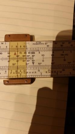
    Using the law of sines to compute the wind correction angle and ground speed for in-flight winds has been used for a long time with flight computers (slide rules.) Photo 1 shows a Russian flight computer.  Working your example on this slide rule, photo 2 shows the cursor placed on the boat speed, 6.5 k, on the top scale (which is a logarithmic scale equivalent to a "K" scale since it covers three cycles.) Photo 3 shows the 30 degree mark on the sine scale on the slide (the center scale on the slide) lined up with the cursor. Photo 4 shows the cursor moved to the current speed, 2.3 k, on the "K" scale and you read out the current correction angle of 10 degrees on the sine scale. Photo 5 shows the cursor moved to 20 on the sine scale (30 degree relative current angle minus the current correction angle of 10 degrees) and reading out the speed over the ground (SOG) of 4.4 k. Photo 6 shows the cursor moved to 40 on the sine scale and reading out the SOG of 8.3 k.

    Your results were:

    current correction angle     = 10.2 degrees
    SOG (current from ahead)    =   4.45 k
    SOG (from the stern)    =            8.35 k
    There are many other scales on both the front and the back. Looking at photo 1, The "K" scale on the slide is used for time-speed- distance calculation, not the 1 our triamgle at the 60 mark and then that scale is marked in hours. The lowest scale on the frame covers one and a half cycles and when the cursor is placed on that scale then the value is squared on the scale immdiately above which is a "K" scale (three cycles.). The adjoining scale on the slide is a tan scale which is then used to compute the radius of turn which varies with the squaare of the air speed and the tan of the angle of bank. The "R in a circle" index above the 4.5 degree mark shows the radius of turn for the input air speed and bank angle and is based on the air speed in kilometers per hour and the radius in meters. I added a pencil "R" mark above the 5 degree mark which then gives the radius of turn with the air speed in knots and the radius in feet.
    Scales on the back make corrections for the airspeed indicator based on altitude and temperature.
    gl


    File:


    File:


    File:


    File:


    File:


    File:


    Reply
    Browse Files

    Drop Files

    NavList

    What is NavList?

    Get a NavList ID Code

    Name:
    (please, no nicknames or handles)
    Email:
    Do you want to receive all group messages by email?
    Yes No

    A NavList ID Code guarantees your identity in NavList posts and allows faster posting of messages.

    Retrieve a NavList ID Code

    Enter the email address associated with your NavList messages. Your NavList code will be emailed to you immediately.
    Email:

    Email Settings

    NavList ID Code:

    Custom Index

    Subject:
    Author:
    Start date: (yyyymm dd)
    End date: (yyyymm dd)

    Visit this site
    Visit this site
    Visit this site
    Visit this site
    Visit this site
    Visit this site