NavList:
A Community Devoted to the Preservation and Practice of Celestial Navigation and Other Methods of Traditional Wayfinding
Re: Traditional navigation by slide rule (correction)
From: Gary LaPook
Date: 2016 Jan 10, 20:50 +0000
From: Gary LaPook <NoReply_LaPook@navlist.net>
To: garylapook@pacbell.net
Sent: Sunday, January 10, 2016 12:39 PM
Subject: [NavList] Re: Traditional navigation by slide rule
Attached File:

(20160110_114506.jpg: Open and save)
Attached File:

(20160110_115803.jpg: Open and save)
Attached File:

(20160110_115824.jpg: Open and save)
From: Gary LaPook
Date: 2016 Jan 10, 20:50 +0000
Correction
" The course is 100 degrees, the wind is coming from 250 so the relative wind angle is 150 degrees. (On a boat this would be a current setting 70 degrees so the relative current angle is 30 degrees):"
From: Gary LaPook <NoReply_LaPook@navlist.net>
To: garylapook@pacbell.net
Sent: Sunday, January 10, 2016 12:39 PM
Subject: [NavList] Re: Traditional navigation by slide rule
You may want to add scales for time-speed- distance computations. Here is a link to an image of a Soviet flight navigation sliderule:
The top scale is a "K" scale (three cycles) that allows for speeds from 1 knot to 1,000 knots. Like on an E-6B, the scale above 100 minutes is marked to indicate hours, the 120 is marked "2" etc. On the matching scale the 60 is marked with a pointer since this represents one hour, just like an E-6B. You could do something similar, using matching "A" and "B" scales covering a range of 1 to 100 knots or even use folded "C" and "D" scales to cover say 2 knots to 20 knots ( or, using standard folded scales, from 3.14159 knots to 31.4159 knots.)
The next scale down in the center of the slide is a sine scale that is used in conjunction with the "K" scale to do wind correction angle and groundspeed computions (set and drift for boaters) utilizing the law of sines. You line up your air speed with the relative angle of the wind (or currrent), move the cursor to the speed of the wind (current) and read out the wind correction angle on the sine scale. Then add or subtract this wind correction angle to the relative wind (current) angle, move the cursor to that angle and read out your groundspeed (speed over the bottom) on the "K" scale.
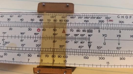
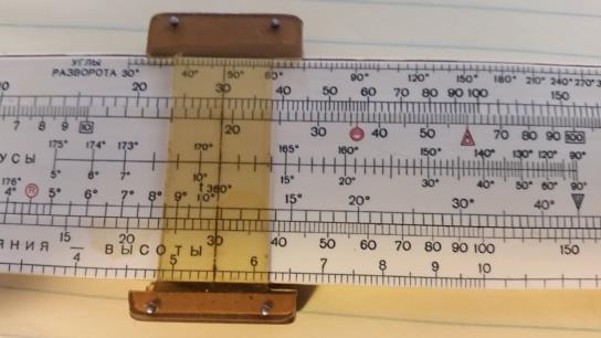
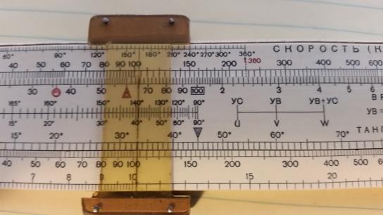
I am attaching three photos of mine to illustrate this. The course is 100 degrees, the wind is coming from 250 so the relative wind angle is 150 degrees. (On a boat this would be a current setting 70 degrees so the relative current angle is 30 degrees) Using 80 knots airspeed and wind speed of 30 knots. (For boats, 8 knot boat speed, relative current angle 30 degrees since current is shown as the direction in which the current is moving, winds are named for the direction they are coming from, and 3 knot current speed.)
The first image shows the cursor lined up on 80 on the "K" scale and 30/150 in the sine scale. Second shows the cursor moved to 30 on the "K" scale and reading out the wind correction angle of 11 degrees. The third image shows the cursor repositioned to 41/139 (11 added to 30 or subtracted from 150) on the sine scale and the groundspeed 104 K (speed over the bottom 10.4 K.) So, to maintain course, the heading of the plane or boat is changed to 111 degrees. We can see that we have a tailwind (following current) so our groundspeed is greater than the air speed. If the wind or current was on the nose then we move the cursor in the opposite diretion when combining the wind correction angle with the relative wind angle to find the groundspeed.
A scale like this might be useful on a navigation sliderule.
When I am training a student pilot in how to do this computation I like to grab his E-6B and say "here, use mine instead" and see that "deer-in-the-headlights" look on his face.
gl
Attached File:

(20160110_114506.jpg: Open and save)
Attached File:

(20160110_115803.jpg: Open and save)
Attached File:

(20160110_115824.jpg: Open and save)


