NavList:
A Community Devoted to the Preservation and Practice of Celestial Navigation and Other Methods of Traditional Wayfinding
From: Frank Reed
Date: 2023 Sep 16, 07:29 -0700
David Pike, you wrote:
"However, further Googling shows Edward Troughton was one of the foremost instrument makers, including astronomical instruments in the UK in the late 18th early 19th century. "
Yes, absolutely! I should probably have mentioned something about Troughton's instrument-making company and its successors. That name on a sextant was like C. Plath in the modern era --a reputation that guaranteed excellence. Troughton's instrument shop produced the best sextants, reflecting circles, and other "mathematical instruments" in that period. As evidence, there was a "Troughton" sextant among the small collection of instruments aboard the Bounty c.1788, and Bligh regularly referred to lunars observed with the Troughton instrument.
You added:
"Therefore, I suggest that this is a demonstrating/teaching device kept in his shop or given as part of the toolkit with one of his measuring circles."
Yes, I agree. These are real possibilities! Myself, I've been trying to think through an educational function (as you say, a "demonstrating/teaching" function) for this mystery device. One aspect that strikes me is that it has a vernier on the sliding scale (cursor on a slide rule, index arm on a sextant) but it also has a finely-divided "transversal" or "diagonal" scale (all those tiny squares). Diagonal scales were passing into obsolescence in the late 18th century, and most sextants and related instruments had delicate vernier scales on them by 1800. Perhaps this was some sort of device to demonstrate the equivalence to navigators interested in upgrading to the latest product from Troughton's shop??
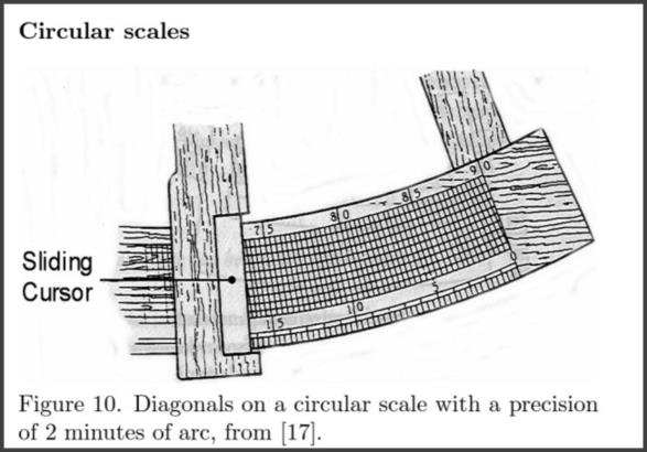
A Wikipedia link led me to a good (old) article on diagonal scales (especially related to slide rules) by Otto van Poelje here (pdf). I'm including one image from that article to illustrate the similarity to the "scale of squares" on the mystery device. Notice that the seemingly vertical lines are actually slightly tilted. That's key to the reading function of "diagonal" scales like this. I don't understand why the "window" on the cursor/slider to view the diagonal scale is so wide on this mystery device. Again, if it's intended purpose is educational, a wide window might be beneficial, but I'm not convinced by that.
Some open questions:
- What is the point of the angular range on this thing? It runs from about -12° to +25° (positive and negative aren't marked but that seems to be the idea).
- The tangent screw (micrometer-like screw) has a scale on the "knob"... Why? There's no pointer to read it...
- Why is the whole thing built on an arc, as Gary LaPook noted? Why would this thing need to be curved? Possibly for education, to make it look like a circular instrument (e.g. sextant) scale, or maybe just because Troughton had the tooling all set up for circular scales.
- If it's not educational, what's the relationship between the vernier scale and the transversal/diagonal scale?
- Was this device attached to some other instrument: a sextant, a theodolite, a telescope mount?
- Why is the scale divided in sub-units of 20? Why not 60?
Having just re-read my post here, I find that I'm convincing myself! Like you, David Pike, I think it's an educational tool --specifically designed to sell new sextants: to aid the transition from old-style transversal/diagonal scales to vernier scales. Verniers were not rare in the late 18th century when this device might have been made, but they may have been seen as "new tech" to some classes of navigators in the market for a fine new Troughton vernier sextant. And seeing is believing.
Frank Reed
Clockwork Mapping / ReedNavigation.com
Conanicut Island USA
PS: Notice that the scale on the octant in the attached image can be read either in altitude or in zenith distance (90°-altitude). There's a scale for each direction.


