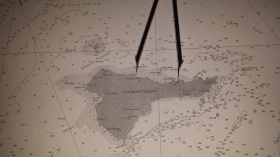
More about Cape Belsham.
Worsley makes specific mention of Cape Belsham in the log. It's a key point for determining his chronometer error, after months on the ice
Therefore, we must examine the data that is contemporaneous to Worsley. I have found a bunch of Sailing Directions that I will list here. Keep in mind that Worsely states his position to be S61°4' W54°50' after all is said and done.
The 1855 Ethiopic of South Atlantic Ocean states Cape Belsham, the N. Point of Elephant Island S60°57' W54°56'
The 1867 Ethiopic of South Atlantic Ocean states Cape Belsham, the N. Point of Elephant Island S60°57' W54°56'
The 1877 Directory of the South Pacific Ocean states Elephant Island, E. Summit S61°6' W54°45'
The 1883 Sailing Directions states Cape Belsham, North point of Elephant Island S60°57' W54°56'
Lets limit ourselves to the three direct contemporaneous references, they clearly state "Cape Belsham, the North Point of Elephant Island". The modern map reference to Cape Belsham is NOT the northern most point of Elephant Island. It's Cape Yelcho. See Image of part of Chart 29104.
In the 2009 discussion of this point, there was a large CE discrepancy, based upon the modern definition of Cape Belsham. The modern day Cape Belsham is 1'15" of arc from Camp Wild. That doesn't align with Worsley's addition to his CE of 1 minute 4 seconds of time.
Dividing the 1 minute 4 seconds of time by 4 seconds per minute of arc in longitude, we get 16 minutes of arc.
I measured 16 minutes of arc with my dividers, and placed one point on Camp Wild. This is a known location. 16 minutes of arc away is a large outcropping near "The White Company" on Chart 29104 King George to Clarence Island. See attached image. Position of the point of this outcropping is S61°5' W55°8'15".
This would have appeared to be the North Point of Elephant Island from Worsley's perspective. It's unlikely he would have been able to see the modern day Cape Yelcho, it's hidden behind that outcropping near The White Company from Worsley's viewpoint.
Modern day Cape Yelcho is another 13 minutes of arc further on at S61°3'45" W55°21'15". That's 27'15" from the positions stated in the Ethiopics for old designation Cape Belsham.
So in a remarkable series of nullifying errors, Worsley misidentified The White Company as Cape Belsham, introducing at 13' error to the east. Modern day Cape Yelcho (old Cape Belsham) is 29 minutes to the west. Worsley introduces a 64 second of time CE, moving him 16 minutes of arc to the east. Which places him right about on modern day Camp Wild.
The images that Robin has produced of the track should be shifted 13' of arc to the east, because
1) Cape Belsham, the North point of Elephant Island is his reference point, modern day Cape Yelcho.
2) 16 minutes of arc from the North Point is where Worsley thinks he is in longitude, consistent with his CE correction.
3) The Ethiopics were wrong
4) Worsley misidentified Cape Belsham
5) the errors cancelled each other!
On the page for May 7th, Worsley notes that the "chron was much slower than I had allowed which made us 20 mile further astern."
Worsley has realized the error in longitude as his course is nearly due east that day. This notation is similar in magnitude to the 13' of arc shown herein.
On May 8th, South Georgia Island is spotted. The note on May 7th must have been written on May 8th. How else would he know his additional CE, than by sight of South Georgia Island.
Brad


