NavList:
A Community Devoted to the Preservation and Practice of Celestial Navigation and Other Methods of Traditional Wayfinding
From: Frank Reed
Date: 2015 Aug 11, 13:54 -0700
Bruce, you wrote:
"I considered temp/pressure correction, but on my trip to the beach there were no significant heat waves from the pavement (or beach) and the weather had been fine/clear for several days. Cape Cod Bay was relatively calm. The horizon was crisp so I concluded "normal conditions"."
Remember that there are two separate things to worry about with respect to refraction and weather conditions. The observations that you describe of local atmospheric effects (heat waves) and the calmness of the bay and the visibly "crisp" horizon are relevant to anomalous refraction which could affect both the dip and the refraction in altitude for very low altitudes (as I mentioned previously, below 1.5° is where you may need to worry about this). But this is distinct from the temperature and pressure correction which you should always consider for sights below 10° and even somewhat higher. Shawn has mentioned the quick calculation that you can perform for this. This is in the calculation section at the back of the modern Nautical Almanac (anyone care to work out the formula for English units?). It's a very simple proportionality: thicker air means more refraction. The air is "thicker" in direct proportion to the absolute temperature and in inverse proportion to the pressure. There's nothing that you can see without instruments at the time of observation to determine this except noting that "normal" good weather usually implies normal temperature and pressure conditions (no guarantee!). You need a a thermometer and a barometer (or an Internet connection... ha!) to calculate this correction.
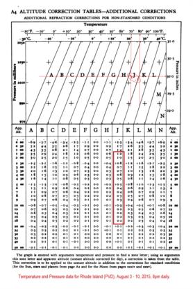
Instead of doing this by calculation, which I do recommend, let's find out the correction using the traditional table, A4, in the Nautical Almanac. I collected the temperature and pressure data for Providence, Rhode Island for the past eight days around the time of sunset and plotted those points on the upper half of the table (see attached image). As you can see they nearly all fall in band "J" --typical conditions for good summer weather in New England. We then consult the lower half of the page and take out the P/T correction from column "J" depending on the observed altitude of the Sun. As you can see, it's about half a minute of arc at 4.5° altitude. The refraction is less than normal because hot air is "thinner" (lower in density so the refraction is reduced in direct proportion). Should you worry about that hald a minute? Maybe. It depends on what sort of accuracy we're looking for.
Note that this temperature and pressure correction is always required. A careful navigator should work up that correction or consult the table for any sights. And note, too, that anomalous refraction is something else that we cannot predict and may be as large or larger than the correction for temperature and pressure.
For sunset sights (presumably non-sextant), you wrote:
"I have done a few sights when the UL touches the horizon. Had reasonable/fair results, but often there is a thin layer of haze."
You may find you get better success here with the lower limb just touching the horizon. I find that I can call the contact better (get the time) than with the disappearance of the upper limb at "actual" sunset.
You added:
"I will try to get another set of data with Hs of about 2 degrees, but I'm thinking I'll use the upper limb."
Certainly the upper limb (with actual sextant sights) is preferred at the lowest altitudes simply because it buys you an extra half degree of altitude above the region of anomalous refraction. This is often apparent in the shape of the Sun at low altitude. If there is an obvious distortion from a "clean" elliptical shape, then you probably have anomalous refraction. Again, this is for altitudes lower than about 1.5°.
You also wrote:
"For various reasons at small angles, I believe greater errors would occur sighting a rising or falling moon? Must look at HP tables?"
I don't see why. Of course you have to do it "right", and the Moon correction tables do confuse many navigators. But they're not that tough, and once you learn how to use them properly, Moon altitudes are every bit as good as Sun altitudes. But beware: this is another case where "lore" often contradicts science. Many experienced navigators will tell you that they cannot get good results with the Moon, and "it's all the Moon's fault".
You were wondering about the "HP tables". Do you mean the Moon altitude correction tables?? The parallax correction for the Moon's altitude is proportional to the HP (from the daily almanac pages) and also proportional to the cosine of altitude. This latter dependence on altitude actually implies that there is less to worry about at low altitudes since the cosine is "flat" (nearly equal to one and changes very slowly) for altitudes close to the horizon. In any case, this is all combined in the standard Nautical Almanac correction table. We don't have to worry about parallax separately. As Gary LaPook has pointed out several times, these tables are probably a little too efficient for their own good, and navigators would probably be more comfortable, and likely more successful, with a more historical format for these corrections where parallax and refraction are treated separately.
Frank Reed
ReedNavigation.com
Conanicut Island USA


