NavList:
A Community Devoted to the Preservation and Practice of Celestial Navigation and Other Methods of Traditional Wayfinding
From: Frank Reed
Date: 2018 Feb 15, 12:24 -0800
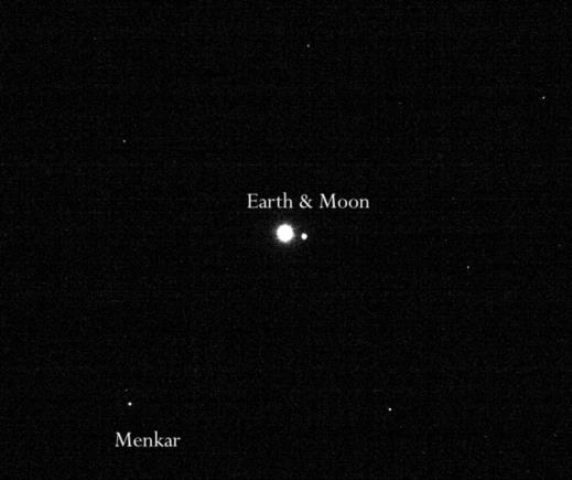
A navigation camera on the OSIRIS-REx asteroid sample return spacecraft photographed the Earth and Moon last month. I've included a portion of the photo below. The full image is here. It's grainy since it's just a navigation image. If you click on the full image on the first page at the NASA link, you'll be taken to a somewhat cleaner version. We can do some navigation with this navigation image! You can figure out where the spacecraft was when the image was taken.
The caption informs us that the photo was taken on January 17 and notes that there are various stars visible including the Pleiades, the navigation star Hamal, and the head of Cetus (so then another navigation star, Menkar). The Earth and Moon are in the middle of the head of Cetus near RA 2h 52m, Dec +6°30'. So then for an observer standing on Earth the spacecraft would be in the sky in the opposite direction: RA 14h 52m, Dec -6°30'. In the photo the Moon is nice and bright which is something no human eye could see on that date since this was the day of New Moon. Given that fact and a little geometry, and measuring the angular distance between the Earth and Moon (a sort of "lunar"), you could estimate your distance away from Earth --or just cheat and use the distance from the caption.
Notice that this sort of deep-space navigation is very similar to piloting a small boat. You split the universe into nearby objects, whose positions will change as you move around, and distant objects, which serve as a backdrop. In this case looking at the position of the Earth against the starry background is quite similar to noticing the position of a nearby buoy in front of a coast in the distance beyond it. The alignment gives us a ray along which our vessel must be located. The apparent size of that nearby object (in this case, the apparent size of the Earth-Moon system) then gives us a rough measure of distance away. If we had an image of another nearby object, maybe Mars, on this date, then we would have two crossing rays which would determine the spacecraft's position relatively well.
Frank Reed
Clockwork Mapping / ReedNavigation.com
Conanicut Island USA


