NavList:
A Community Devoted to the Preservation and Practice of Celestial Navigation and Other Methods of Traditional Wayfinding



From: Frank Reed
Date: 2026 Apr 9, 12:03 -0700
Josh Carty, you wrote:
"I was thinking I might be able to open Pub.249 vol.1, the Selected Stars book, and look for a case that matches the photo. I have an old digital copy of pub249 for the year 2015, and it shows Procyon at 32° 24' with Zn 105 and Sirius at 27° 50' with Zn 134 on the same line. This is for LHA of Aries =60 on the page for 30 N latitude. That's sort of what I'm looking for. Both stars low in the east (not low enough but I can fix that). How do I justify using 60° for LHA of Aries? Should I??? I can try other latitudes on other pages."
Yes, you're on a reasonable path here. You need an estimate of the latitude. You have selected 30°N. That's a good starting point. Next step, as you note, it would be nice to have a good number for LHAa (my notation for LHA Aries). Scanning through the "Selected Stars" volume (Pub.249 vol.1) will work, and yes, you can get very close with an out-of-date volume, as you proposed here. But there's a better way!
You recall, I hope, from the workshops you attended that LHAa is related directly to the coordinates of the meridian. For astronomers, LHAa is actually "Sidereal Time" and that is identical to the R.A. of the meridian. For navigation we prefer SHA over RA, but the concept is the same: for any star, RA+SHA add up to 360°.
The LHA of Aries or the SHA of the meridian provide us with fundamental orientation information for the sky over our heads. If I give you a latitude, that tells you the rotation/orientation of the sky in the North/South direction, and we often make that tangible by saying that the latitude tells us the height of Polaris in the northern sky. Similarly, if I give the LHA of Aries (LHAa) or the SHA of the local meridian (SHAmer), that tells you the orientation of the sky in the East/West direction. Those two parameters together, latitude and LHAa (or equivalently SHAmer) tell us everything we need to know to describe (or simulate) the sky. That's why I like to say that each line in Pub.249 vol.1 is like a little paper planetarium that we "align" by entering with latitude and LHA of Aries of our choice. It provides the altitudes (Hc) and bearings/azimuths (Zn) of seven "selected" stars, and that's a complete specification of the sky (in fact, it's over-specified with seven stars; fewer would work).
You say you want the LHAa for the photo. Of course, it's "not there". We can't "read" LHAa directly from the sky. Ah, but we can read the SHA of the meridian, and we can also read the SHA of the East Point (90° azimuth) and the West Point (270° azimuth) on the horizon. How are these things related? I'll just give a list for now, and you can work it out, or we can talk about it later:
- SHAmer + LHAa = 360°
- SHAwp + LHAa = 90°
- SHAbp + LHAa = 180°
- SHAep + LHAa = 270°
Here, SHAwp is the SHA of the stars on the horizon at the "west point", exactly due west, SHAep is the same for the "east point". One I didn't mention yet: SHAbp is the SHA of stars on the meridian "below the pole". All of these various SHA quantities are observable! We can "read" the SHA of the meridian by looking at the sky. And we can read the SHA of the east point by looking at the sky. Once you have either of those (or any in the set of four above), then LHAa follows immediately. And yes, once you have LHAa, you're almost set up with the equivalent of an assumed position to do a standard, easy position fix.
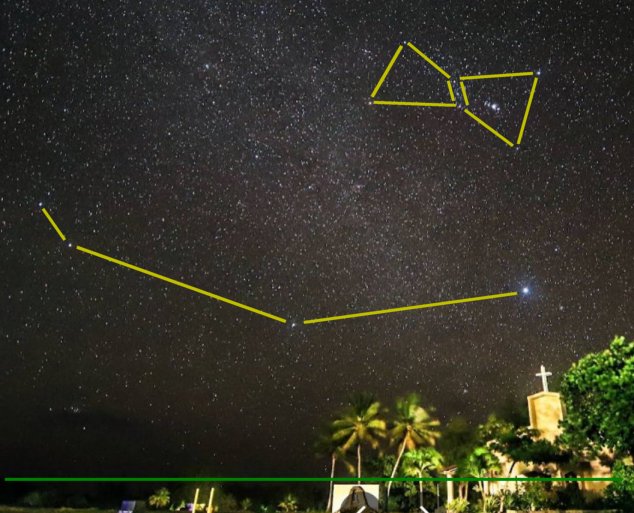
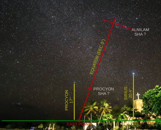
Reading the SHA off the sky means looking at a star chart, or at least looking at the coordinates of the stars. In the case of this photo, it is worth knowing that Mintaka, the top star or Orion's Belt in the photo is less than 1° from the celestial equator (its Dec = -0.3°), and the star Procyon is about 5° from the celestial equator (its Dec = 5.2°). So you can draw a line from Mintaka passing below Procyon (scale from the size of Orion!), and the spot where it hits the estimated horizon is the East Point. For any (and every) latitude, this is true. The celestial equator runs from East Point to West Point -- exactly due to east, 090°, to exactly due west, 270°.
I'm attaching a couple of markups of that original Pacific island photo to indicate the process ...without giving away too much of the end game. Let me know how it goes! And no, you do not need to do one drop of new spherical trigonometry to solve this, though of course that can be fun, too.
Frank Reed
Clockwork Mapping / ReedNavigation.com
Conanicut Island USA
Reminder: Pacific sessions of my workshops begin on Monday, April 13. Schedule on ReedNavigation.com.