NavList:
A Community Devoted to the Preservation and Practice of Celestial Navigation and Other Methods of Traditional Wayfinding



From: Joshua Carty
Date: 2026 Apr 13, 10:32 -0700
WAKE ISLAND! I don't think anyone posted the location yet. It has to be Wake.
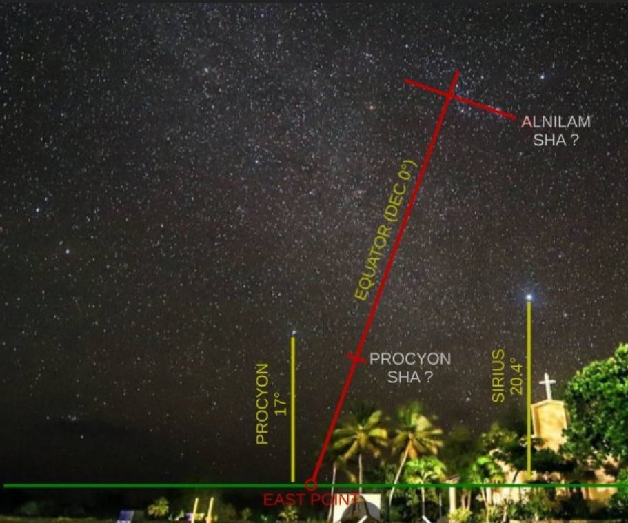
I took your markup image and followed your advice. With the SHA of Alnilam and Procyon I put the horizon at the EAST cardinal point at SHA=230°. Next I used your rule (which I think I understand!!): SHAep + LHAa = 270°. That means LHA of Aries is 40°.
To simulate the sky, I went to the equator and the prime meridian. At the prime meridian LHA Aries is THE SAME THING as GHA Aries (thats huge!). I forced GHA Aries to 40° by setting UT on 11 apr 2026 (arbitrary!), to 13:21. Close enough. That makes the SHA at the east point 230°, just like in the photo. And that puts Sirius and Procyon low in the eastern sky. Great!
Next I tried different latitudes to match the estimated altitudes of the two stars. Using your horizon line (the green line) and measuring distances on the photo and comparing to the "meter stick" of the Betelgeuse-Rigel distance, I agree with your numbers.
Procyon ....... 17°
Sirius ........... 20.4°
It occurred to me that your horizon line is an estimate so what I need to find is a latitude where the DIFFERENCE in those altitudes is 3.4° and not those precise altitudes. Like you have described changing latitude rotates the sky around a pin stuck in the sky at due east. I started at the equator and calculated altitudes every 5° heading north....
Lat diff
0 12.3
5 10.2
10 8
15 5.8
20 3.6
25 1.3
30 -0.9
At the equator Sirius is over 12 degrees higher than Procyon. At latitude 30, Sirius is lower than Procyon. For the difference I need it looks loks like 20° is close. I tried the tenths and got a best match at latitude 20.4°N.
I go to the Pacific in Google Maps. With your longitude of 165° E and this latitude 20.4° N, I'm not far from Wake Island and a long way from any other islands. I suppose if the altitudes were more accurate (but not possible in a photo like this probably) the latitude would be right at the island.
So I was feeling pretty good here... Got it all worked out. Nice. Easy except I needed to use a software tool (Stellarium) to generate the altitude diffs. But then it dawned on me. You made this OBVIOUS but I didn't see it until after I did it this way. This calculation with altitudes works great, but the latitude is right there in the image that you already presented!! It's the tilt of the celestial equator. Wow. I grabbed a protractor... (oh I don't have a protractor). I grabbed pixel coordinates from the celestial equator red line and got the inclination of the equator from a simple inv.tan(x/y). That comes out to 19.3°. That's amazing! Right on the latitude of Wake Island.
No spherical trigonometry... just draw in the celestial equator based on known positions of stars visible in the photo and find it's tilt relative to the prime vertical. It occurs to me now that the local prime vertical is probably the greatest uncertainty .... no way to "swing the arc" with an iPhone! So there's a fair amount of good luck in my latitude here. BUT HEY safely within a degree of the latitude of Wake.
J