NavList:
A Community Devoted to the Preservation and Practice of Celestial Navigation and Other Methods of Traditional Wayfinding
Re: William Bourne. A Regiment for the Sea. 1574
From: George Huxtable
Date: 2009 Oct 15, 13:01 +0100
From: George Huxtable
Date: 2009 Oct 15, 13:01 +0100
Brad has made a really good transcript of William Bourne's chapter 6 of his
"Regiment for the Sea" of 1574. Doesn't it make interesting reading?

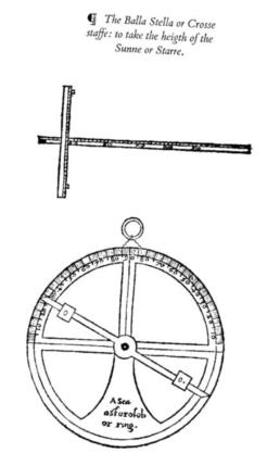
To back it up, attached is a copy of Bourne's diagram, from  E G R Taylor's
Hakluyt Society 1964 transcription, referred to by Nicolas, of the
cross-staff or balestilla, and the mariners astrolabe or sea-ring.

A few notes follow, for anyone interested.

The word "Regiment" has a very different meaning from its present one; it's
used here with the meaning of "a set of rules".

The "glasses" he referred to in connection with the cross-staff were a
recent introduction: a small piece of dark glass at the upper end of the
transom to protect the eye from the Sun's glare. Without such a shade, the
observer had to do his best to shield his eye from the Sun by the tip of the
transom itself, while just allowing a sliver to appear; an almost-impossible
task in a rolling vessel. I'm not sure why he writes "glasses", in the
plural, rather than "glass", unless there was another to control a dazzly
horizon. His suggestion, of trimming the end of the stick to suit the
geometry of an observer's eye and skull, which caused some argument at the
time, was discussed recently on Navlist.

"Charles' Wain" may be unfamiliar: it's the old name for what we in Britain
now call the Plough, and Americans the Big Dipper, Ursa Major. The use of
the Pointers, in relation to Polaris, was important in those days, as
Polaris was then nearly three degrees from the true Pole. When the Pointers
were aligned as explained, Polaris would be aligned reasonably well with
true North.

Bourne was properly sceptical that the notion that measurement of magnetic
variation could be a useful way to determine longitude, an illusion that
persisted for another 150 years or so until it was finally abandoned. There
were, however, special places such as the Cape of Good Hope, where it was
indeed of use.

What's specially interesting about Bourne was that he wasn't himself a
navigator, or even a mariner at all, and made no claim to be. He was a
gunner (and therefore, a surveyor also), at a fort on the lower Thames, and
later a successful innkeeper, though he was, no doubt, mathematacilly able.
His book is far from being original. Much of it had been taken (and so
acknowledged) from "La Arte de Navigar" by Martin Cortes, which had been
written in Spanish in 1551, and a translation into English by Richard Eden
had been published in 1561. Bourne's own contributions, however, were very
perceptive

Much of the information above has come from Taylor.

George.

contact George Huxtable, at  george@hux.me.uk
or at +44 1865 820222 (from UK, 01865 820222)
or at 1 Sandy Lane, Southmoor, Abingdon, Oxon OX13 5HX, UK.

--~--~---------~--~----~------------~-------~--~----~
NavList message boards: www.fer3.com/arc
Or post by email to: NavList@fer3.com
To , email NavList+@fer3.com
-~----------~----~----~----~------~----~------~--~---


