NavList:
A Community Devoted to the Preservation and Practice of Celestial Navigation and Other Methods of Traditional Wayfinding
From: Frank Reed
Date: 2023 Jan 9, 06:36 -0800
David P, you wrote:
"There wouldn't be much sense planting a tower on poor base rock just to make the surface mosaic perfect."
I agree that it's a concern, but this is mega-engineering. They can move the rocks. I was intrigued to discover that an early phase of the project was "boulder re-placement". They picked up all the giant rocks and moved them around, making sure that they weren't piled all in one place so as to avoid creating new reefs. Then they compiled all the new locations and published them for fishing interests. I don't really understand the planners' devotion to the perfect "surface mosaic" that you mentioned. In fact I could imagine real benefits to a more randomized grid. But farmers must plant their crops in rows, and millennia of tradition may be the biggest aesthetic motivation here!
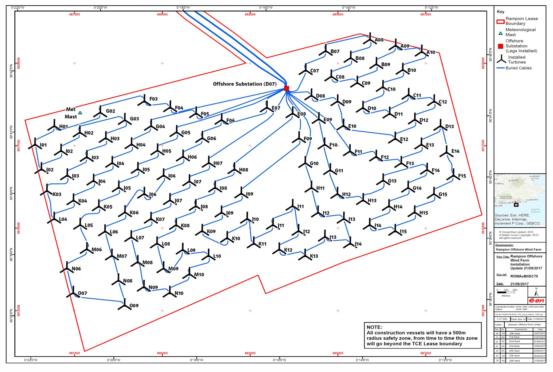
There are better charts available (of course --the turbines are fairly significant navigational hazards!). I found one on the Rampion Wind Farm site that I'm attaching below. It has proper lat/lon markings, and the positions of the individual turbines can be determined. Although this chart is dated 2017, it does seem to show the full array of turbines. From this chart I can revise a few distances:
- Pagham beach to turbine J01: 15.8 nautical miles. I previously suggested 14.8.
- From one turbine to the next (down true azimuth 103.4°): 0.42 nautical miles.
- Between rows (measured from the axis of one row to the next on azimuth 193.4°): 0.37 nautical miles. I previously suggested 0.356.
Frank Reed


