NavList:
A Community Devoted to the Preservation and Practice of Celestial Navigation and Other Methods of Traditional Wayfinding
From: Frank Reed
Date: 2023 Jan 18, 10:49 -0800
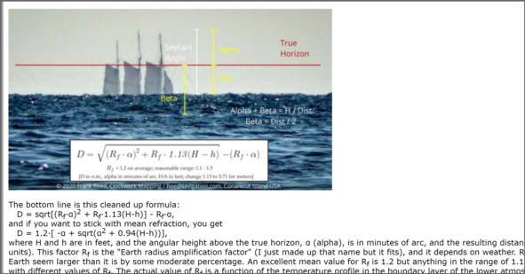
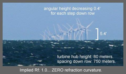
I spent some time in the past few days measuring angles on the original photo and then running the analysis of the refraction. The results are interesting. Assuming the first turbine tower in view, probably in row H or I rather than row J, is 15.85 nautical miles away, and assuming the physical height of each turbine hub is 80 meters while the observer's height of eye is about 5.2 meters (give or take... that's the number that gives me the most consistent results), then I can determine from the photo the best value of Rf, that "earth radius amplification factor" that I described previously. The best value for Rf is 1.0. That's no amplification from refraction at all, implying that light rays (photons) are travelling in straight lines.
Why is there no refraction in this situation? Normally when we look out toward the sea horizon and see vessels or structures beyond, they are lifted up slightly because light rays curve as they travel towards us. We can see beyond the horizon more than simple straight line geometry would predict. Mathematically we can remove that curvature of light rays by taking our purely Euclidean equations for dip and angles beyond the horizon and replacing the usual radius of the Earth, R, wherever we find it with a slightly increased radius Rf·R where the "earth radius amplification factor", Rf, is typically 1.2 but values between 1.1 and 1.5 are not unusual (and even values outside that range are not rare). The refraction is caused by layering in the "boundary layer" --that part of the atmosphere, on the order of 100 to 300 meters thick, close to the sea surface, distinct from and more variable than the rest of the troposphere. The density layering in the boundary layer is almost entirely the result of the declining temperature of the air with height which also continues in the rest of the troposphere (up to an altitude of roughly 6 nautical miles, until we hit the tropopause). But the layering doesn't have to display declining temperature with height above the sea. It can increase due to a temperature inversion. That will normally result in a greater gradient of density and larger values for Rf. In practical terms, we get larger smaller dip values and we can see farther when there is a temperature inversion (or even if it's just "leaning" in that direction away from mean conditions).
In this case, we see nothing like a temperature inversion. Not a larger value of Rf, but instead the photo implies that Rf is essentially one, 1.0, no refractive effect. It's as if the air has been thoroughly mixed in the boundary layer. Now what could doing that? What could mixing the air in this photo?
An obvious possibility here is that we are seeing a natural result of the wind farm itself churning the atmosphere's boundary layer and eliminating the usual temperature layering. This would yield a value for Rf close to 1. This impacts what we see locally, reducing the range to the horizon somewhat, and it also would have an impact on celestial navigation. The factor Rf is implicit in the dip formula, and if Rf is one, then the usual dip formula (in feet for now) would be 1.06·sqrt(height of eye), like Euclidean geometry predicts, instead of the more familiar 0.97·sqrt(height of eye), which incorporates the effect of refraction. For a height of eye of 120 feet, this would shift the value of the dip by one full minute of arc. At a height of 30 feet (lower by a factor of four), the impact on the dip would be half a minute of arc (reduced by a factor of two). So change your dip table if you're doing celestial out there among the turbines of the giant wind farms! :)
I should note that "normal" weather variability could also yield a value for Rf of 1, but it seems a little too coincidental in context here. Plus the concept makes good physical sense.
Frank Reed
Clockwork Mapping / ReedNavigation.com
Conanicut Island USA


