NavList:
A Community Devoted to the Preservation and Practice of Celestial Navigation and Other Methods of Traditional Wayfinding
From: Matus Tejiscak
Date: 2024 Feb 20, 11:56 -0800
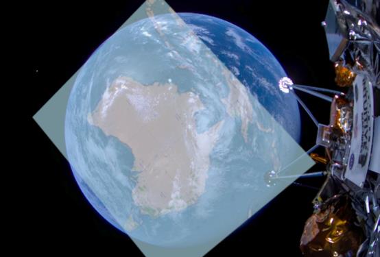
The easier part is fitting a circle on the image of the Earth and finding its centre. The harder part is massaging a map of Australia to fit the image of Australia, because of the various distortions involved -- whatever your fit, it will be incorrect in some aspect. Once you squeeze the picture in there somehow, you get the attached image, with the red cross indicating the centre of the circle. A rough comparison with the map shows the circle somewhere around 19.3° S 137.0° E. I'd guesstimate the error to be no greater than one degree in latitude or longitude, but it's hard to tell, given all the distortions.
From the length of a segment connecting coastal features on opposite sides of the continent (1800 km), its apparent size (212 px), the actual radius of the Earth and the apparent radius of the Earth (359 px), and some algebra, you can get an equation that numerically solves to the altitude of about 3800 km above surface. Increasing the apparent size of the segment by 10 px decreases the solution by about 500km, so I'd call that the uncertainty of altitude.
So, neglecting a lot to simplify, my guess would be Lat = 19.3° S, Lon = 137.0° E, Alt = 3800 km. That's some 200 km NNW of the clue in the file name, Alpurrurulam, and seems to be a bit to the southwest of Tibor Miseta's solution.
Matus


