Welcome to the NavList Message Boards.

NavList:

A Community Devoted to the Preservation and Practice of Celestial Navigation and Other Methods of Traditional Wayfinding

Compose Your Message

Message:αβγ
Message:abc
Add Images & Files
    Name or NavList Code:
    Email:
       
    Reply
    Re: A little space navigation
    From: Sean C
    Date: 2018 Oct 5, 01:36 -0700

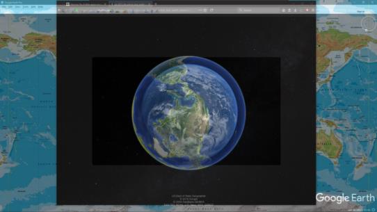
    I used a program called Glass2K to make Google Earth transparent and then overlayed it on the image. I had to make the Earth appear about 20% bigger in Google Earth than in the image to make the continents line up. When I zoomed in, I was over a point just north of a town called Blossom, Texas: 33°41.800' N, 95°22.415' W.

    In the lower right corner of the attached overlay image, you can see an "eye alt" of 19,111.43 mi. However, this is meaningless because if I had zoomed the image in or out I would have had to change the altitude in Google Earth.
    File:


    File:


    Reply
    Browse Files

    Drop Files

    NavList

    What is NavList?

    Get a NavList ID Code

    Name:
    (please, no nicknames or handles)
    Email:
    Do you want to receive all group messages by email?
    Yes No

    A NavList ID Code guarantees your identity in NavList posts and allows faster posting of messages.

    Retrieve a NavList ID Code

    Enter the email address associated with your NavList messages. Your NavList code will be emailed to you immediately.
    Email:

    Email Settings

    NavList ID Code:

    Custom Index

    Subject:
    Author:
    Start date: (yyyymm dd)
    End date: (yyyymm dd)

    Visit this site
    Visit this site
    Visit this site
    Visit this site
    Visit this site
    Visit this site