NavList:
A Community Devoted to the Preservation and Practice of Celestial Navigation and Other Methods of Traditional Wayfinding
From: Frank Reed
Date: 2019 Jan 2, 16:14 -0800
Ed,
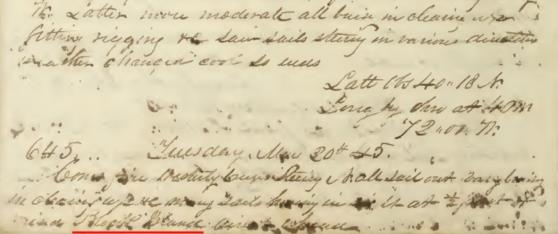
You did see that I said the vessel was returning to New England, right? So a latitude of nearly 27° on Tuesday followed by a latitude of nearly 21° on Wednesday is clearly wrong. In fact, if you look more closely, the latitude that you read as 20°57' on Wednesday is 28°57' (eights are tough in historical manuscripts!). Thus the change in position is something like 135 nautical miles in 24 hours implying a speed of about 5.6 knots, which is quite reasonable.
This logbook ends seven days after that lunar-based longitude, on Tuesday, May 20, 1845. It's a "splotchy" entry without much detail, but if you look in the image below, you can see one key phrase: Block Island. They have sighted land. They are home. And yes, the numbers on each date appear to be days at sea -- a simple day count. What else could they be? The voyage ends on day 645, a little more than 21 months away from New England.
Lunars were not frequently taken in this period, and yet we see almost exactly the same end-of-voyage pattern aboard the Charles W. Morgan which arrived back in New England on January 1, 1845 at the end of its first whaling voyage. About two weeks out, they also shot lunars (two days in a row). I have speculated that there is a simple purpose here. The vessel's hold is completely filled with barrels of whale oil. That's why they're homeward bound. They've got all they can get. That whale oil is valuable treasure. Risking shipwreck at the very end of the voyage would be foolish, so double-checking the longitude a week or two out demonstrates responsible, prudent navigation.
Frank Reed


