NavList:
A Community Devoted to the Preservation and Practice of Celestial Navigation and Other Methods of Traditional Wayfinding
From: Frank Reed
Date: 2022 Aug 7, 15:15 -0700
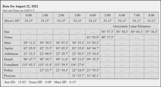
Let's shoot a vertical lunar. Around 03:37 UT in the middle of nautical twilight on 22 aug 2022, somewhere in Liechtenstein (chosen for alliteration!), you shoot a lunar from the star Procyon to the Moon's near limb. The Moon is directly above Procyon, both on an azimuth of 93° T (+/-1°). The Moon's LL is 40° 29' high. Procyon is 10° 19' in altitude, just peeking over a nearby mountain. No dip correction. Assume typical pre-dawn weather for lowland Liechtenstein. Count these as low quality altitudes, +/- 5' or even worse. You measure as near as simultaneously as possible the Procyon-Moon angular separation and you find 30° 09.8'. This is a high-quality observation with a good metal sextant equipped with a 7x scope, so you may assume that it is accurate to the nearest tenth of a minute of arc. I'm attaching the usual "almanac data" for the Moon's HP and the pre-computed geocentric lunar distances.
What is your best estimate of the actual UT from this observation? What are the sources of error that you should worry about? You should be able to clear this lunar distance with almost no trigonometry and no tables beyond the usual altitude corrections. That's because this is a "vertical" lunar.
Reminder: https://clockwk.com/apps/clear/.
Frank Reed
Clockwork Mapping / ReedNavigation.com
Conanicut Island USA


