NavList:
A Community Devoted to the Preservation and Practice of Celestial Navigation and Other Methods of Traditional Wayfinding
New compact backup CELNAV system (changed for archive)
From: UNK
Date: 2009 Feb 24, 12:06 -0800
From: UNK
Date: 2009 Feb 24, 12:06 -0800
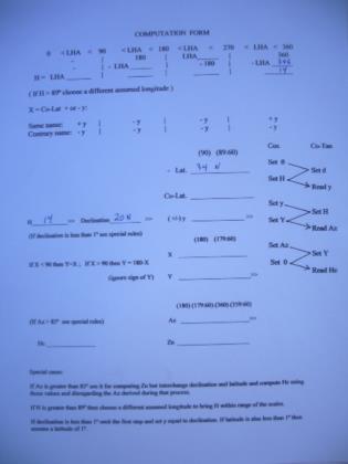
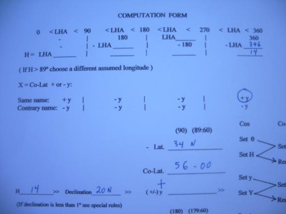
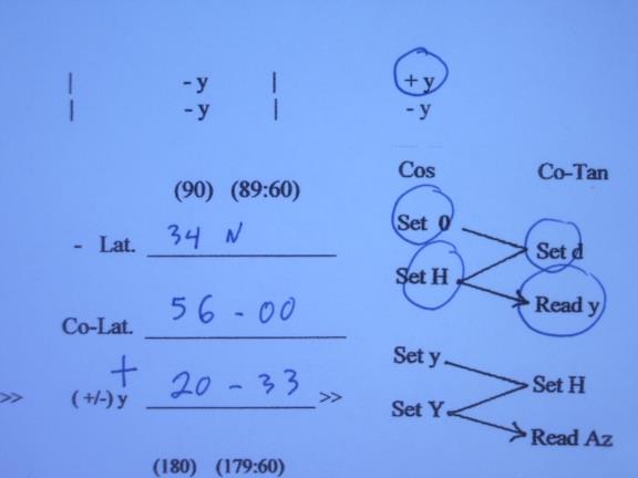
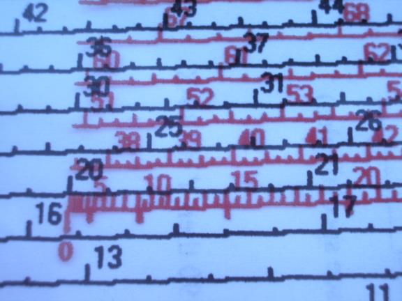
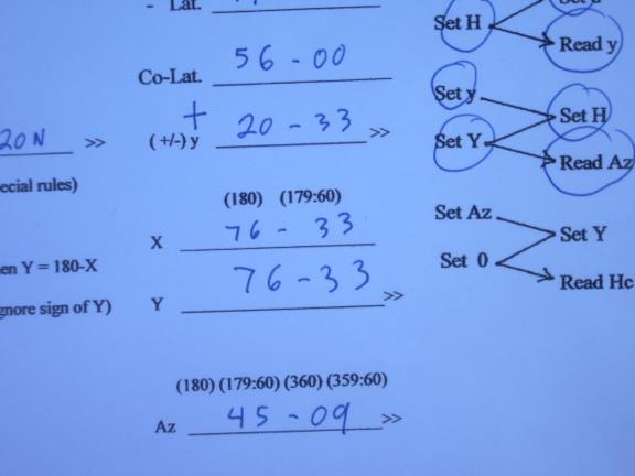
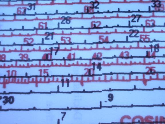
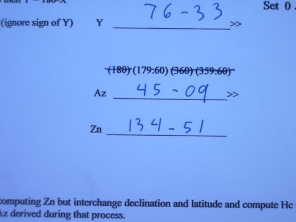
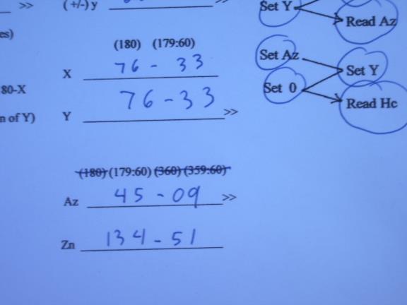
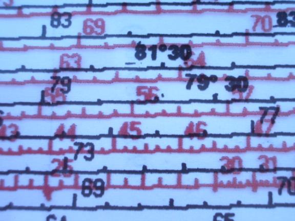
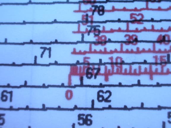
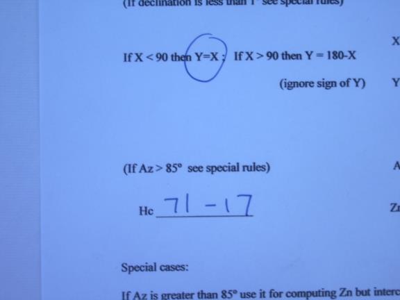
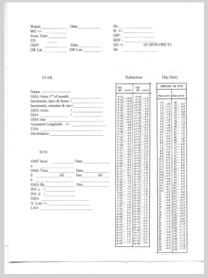
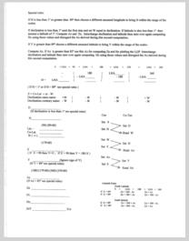
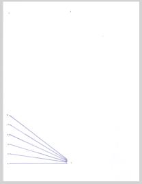
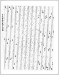
There are often posts on the Navlist regarding using celestial as a backup to GPS and finding a simple way to do this. I think I have found a method that is simple, self contained, takes up little space, needs no almanac or sight reduction tables and requires no batteries. This method is meant for those who already know celestial navigation and provides a very compact and self-contained system needing no books, almanacs or tables. The first part of the kit is simply the long term almanac from H.O. 249 along with the Polaris tables and the Precession & Nutation table to allow the use of the tabulated coordinates for the stars for a long period of time. Since this almanac only covers the sun and the stars no provision is made for handling planets or the moon but that is not that important for a "backup" celestial method.. However, if you have the Nautical Almanac then you can work with these bodies as well. I have included a form to use with the long term almanac which also includes tables for correction of observations. The long term almanac consists of nine pages from H.O. 249 plus a computation form which can be printed back to back on only five sheets of paper. The main part of this method relies on my adaptation of the long extinct Bygrave slide Rule which is elegant in its simplicity but which produces altitudes and azimuths within in one or two minutes of arc and takes less than two minutes to do the computation. I have included three PDF files that can be printed out to create a working copy of my adaptation which consists of three sheets containing the modified scales which can be hole punched and kept in a thin three ring binder (or in an envelope) with the long term almanac and extra forms for recording the computation. The Cotangent scale should be printed out on paper and can be sealed in a plastic sheet for good durability. The Cosine scale and the Vernier are printed out on plastic transparency sheets in an inkjet printer and can also be sealed in additional plastic sheets for durability. The entire backup method is contained on a total of only eight sheets, five for the almanac and three for the Bygrave slide rule! When using the Bygrave slide rule the azimuth and altitude are calculated in three steps using the same manipulations of the slide rule for each step. I will first describe the use of the normal cylindrical Bygrave slide rule which utilizes a cursor or pointers to align the scales. I have also enclosed a copy of the original Bygrave instruction book. The Bygrave has also been discussed on the Navlist. We first calculate the intermediate value "y" (lower case y) which is found by the formula: tan y = tan declination / cos H (H = Hour angle) This is the formula listed in the Bygrave manual but, in fact, the slide rule does the calculation by modifying this formula to allow the use of the cotangent scale. The actual manipulation of the slide rule uses the re-arranged formula of: cotan y = cotan declination x cos H You accomplish this computation by setting one of the pointers (or the cursor on my copy) to zero on the cosine scale and while holding it there rotate the cosine scale and slide it up or down on the cotangent scale so that the other pointer (or cursor) is aligned with the declination on the cotangent scale. Now, holding the cosine scale still, rotate the pointer (cursor) to point at the hour angle (H) on the cosine scale and then read out "y" from the other pointer (cursor) where it points on the cotangent scale. Next you find the second intermediate value,"Y" (upper case Y) by adding "y" to co-latitude (if latitude and declination have the same name) or by subtracting "y" from co-latitude (if of opposite names.) [I kept the original nomenclature from Bygrave so that the original literature can be followed . I think it is confusing to use the same letter of the alphabet for two variables, "y" lower case y, and "Y" upper case Y, and I don't know why Bygrave chose this system. I prefer to replace "y" with "W" in the formulas and have done so on my forms.] Next we find azimuth with the formula : tan Az = (tan H x cos y ) / cos Y which is re-arranged into the form: cot Az = (cotan H / cos y ) x cos Y Using the same manipulations as before, set one pointer to "y" on the cosine scale and the other pointer on H on the cotangent scale, move the cursor to "Y" on the cosine scale and read out azimuth from the other pointer on the cotangent scale. The third step calculates altitude, Hc. using the formula: tan Hc = cos Az x tan Y with the formula re-arranged into the form: cot Hc = cot Y / cos Az set one pointer to Az on the cosine scale with the other pointer to "Y" on the cotangent scale. move the pointer to zero on the cosine scale and read out Hc from the other pointer on the cotangent scale. I have developed an even simpler implementation of the Bygrave, one that is very easy to make since it doesn't require concentric tubes. I made this by printing out the cotangent scale twice on a piece of paper. I then printed the cosine scale in red on a transparent sheet so that the cosine scale can be placed directly on top of the cotangent scale and aligned much like a normal slide rule. We follow the same steps as already described but it is even simpler since no cursor needs to be used. I will illustrate how easy it is to use with an example. I have include a form and pictures of the scales showing this computation. Since the Bygrave doesn't require that the latitude or the LHA to be whole degrees you can compute Hc for your D.R. position but for convenience in this example we will use 34� N for latitude, for declination, 14� N and the LHA is 346�. Look at illustration number 1 (i.jpg) which shows the form to be used with this simplified model of the Bygrave. The top of the form is used to compute hour angle, "H", in the range of 0� through 90�. You enter the LHA in the proper column and make the computation. You can see in our example we have placed the LHA, 346�, in the column for LHAs in the range of 270� to 360�. The form shows that in this case we subtract LHA from 360� to find "H", hour angle, in this example, 14�. We have carried this 14� down to the "H" blank on the form and we have entered declination and latitude in the appropriate blanks.(2.jpg) [The scales on the original Bygrave ran from 20' up to 89� 40' and then back in the reverse direction from 90�20' to 179�40'. My simplified version eliminates the second set of numbers keeping the scale less cluttered. The original Bygrave allowed hour angles of 0� to 180� east and west (which had been normal celestial practice prior to the introduction of the concept of LHA) but because my version eliminated the second set of numbering on the scales it is necessary to get hour angle, "H", into the range of 0� and 90� which is accomplished on the top part of the form. Other changes were also necessary because of my simplification of the scales and they will be pointed out later.] (To avoid confusion I have switched to using "W" to replace Captain Bygrave's lower case "y.") Next we subtract the latitude from 90� to form co-latitude. If we were using our D.R. latitude we would subtract it from 89� 60' since this notation makes it easy to subtract degrees and minutes. In our example the co-latitude is 56�. We use the top of the form to determine if we will be adding or subtracting the intermediate value of "W" to co-latitude. This is determined by the column of the LHA and by the names of the latitude and declination. In our example we can see that we will be adding "W" since LHA is in the last column and the names of the latitude and the declination are the same. Just circle the "+" mark at the bottom of this column and also place a "+" mark on the "W" line under the co-latitude line.(3,4 and 5.jpg) [With the original Bygrave you always added if latitude and declination had the same name and subtracted if of opposite names. Because of my simplified scales you must subtract "W" if same name and LHA between 90� and 270�, and the form accomplishes this. This puts you at exactly the same place on the scales as with the original Bygrave. You still always subtract if of opposite names.] Next we will follow the zig-zag diagram along the right edge of the form to find the value of "W". The left side of the zig-zag indicates the cosine scale and the right side indicates the cotangent scale. The same process is used three times and values are always taken off from the cotangent scale, never from the cosine scale. The zig-zag tells us to line up 0 (zero) on the red cosine scale with "D" (declination) on the black cotangent scale. We then look at "H" (hour angle) on the red scale and take out "W" from the adjacent cotangent scale. (6.jpg) On both scales the numbering is above and to the right of the marks on the scales. I have aligned the red cosine scale slightly below the black cotangent scale for clarity. We can see that the red zero is lined up directly below the black tick mark for 20� (the declination). You usually use visual interpolation for the minutes of declination. Now, without allowing the scales to shift, we locate "H" on the red scale and read out "W" from the adjacent black scale, in this case 20� 33', and write this value on the "W" line below the co-latitude. (7.jpg) Next we find he second intermediate value, "Y", by first determining "X" by adding "W" to co-latitude, in this example "X" = 76� 33'. Then, following the rule on the form, since "X" < 90 then "Y" = "X" and we carry it down to the "Y" line. If "X" > 90 we would subtract "X" from 180� (or from 179-60) to form "Y". [I introduced this new intermediate variable "X" so that the resulting "Y" will be less than 90� which allowed me to keep the scales less cluttered since the reverse numbering, 90�20' to 179� 40', found on the original Bygrave is not needed.](8 and 9.jpg) We now follow the second zig-zag to find Az . (Note we start with the value computed at the last step, "W.") (10.jpg) Using the same manipulation as the first time, we line up "W" on the red scale with "H" on the black scale . We than look at "Y" on the red scale and take out Az from the adjacent black scale. Looking at illustration 11 (11.jpg), we have lined up red 20-33 with black 14 by aligning the 20-30 mark slightly to the left of the "14" on the cotangent scale. (Remember at this point on the red scale the short tick marks show 1/2 degree or 30'.) Next we located "Y" on the red scale (76-33) and take out the Az from the black scale. (12.jpg) (The red 76-30 mark is lightly to the left of the black 45 tick mark and the red 76-40 is aligned with the black 45-20 so by visual interpolation the red 76-33 will align with the black 45-09, the Az. (At this point on the scales each tick mark is 10'.) Next enter the Az on the form and compute Zn by applying the rules on the attached form, in this case the celestial body is to the south east so we subtract Az from 180� (179-60) to determine Zn, 134� 51' (or 134.9�).(13.jpg) [Because of my simplified scales the determination of Zn is different than with the original Bygrave since you can only read out Az in the range of 0� to 90� with my version while on the original Bygrave the Az was taken out in the range of 0� to 180�. The determination of Zn is usually not a problem in real life since you know the approximate direction of the body when you take the sight. I have include rules to resolve any ambiguity.] We now follow the last zig-zag to calculate Hc. ( Note we again start with the value computed at the last step, Az). (14.jpg) Using the same manipulation as before, we line up Az on the red scale with "Y" on the black scale. Next we locate zero on the red scale and take out the Hc from the adjacent black scale. Looking at no. 15 (15.jpg) we see that we have aligned he red 45 tick mark slightly to the right of the black 76-30 (each tick mark is 10' on both scales) and we visually interpolate red 45-09 with black 76-33. Looking now at no. 16 16.jpg), we find the red zero and interpolate on the black scale to take out the Hc of 71� 17'and enter it on the form. (17.jpg) Comparing our result with H.O. 249 (see no. 18, 18.jpg) we find the Hc in H.O 249 of 71� 17' and Zn of 135�, the same as with the Bygrave. The original Bygrave had a cotangent scale marked every one minute of arc while the cotangent scale of my reproduction is marked every ten minutes and in some cases every five minutes. The original cosine scale was marked at varying spacing and my recreation is also, but not as frequently as on the original. At most places on these scales it is sufficiently accurate to visually interpolate. However, at places where the scale markings are far apart, visual interpolation is not accurate enough. To improve the accuracy of my reproduction I have added a scale that assists in interpolation. This scale consists of a small diagram with converging numbered lines and should be used on the cosine scale above 80� and on the cotangent scale above 80� and below 10�. To use it slide it up until the outside lines, labeled zero and ten, fit between two marks on the main scales and then use the intermediate lines for the interpolation. In most cases it is not necessary to use this vernier. If the scales were more finely divided this Vernier could be dispensed with completely. There are some unusual cases that require slightly different procedures and all of these special cases are described on the form. If "H" is less than 1� or greater than 89� (actually 89� 15' on my version) simply assume a longitude to bring "H" within the range of the scales. The intercept will be longer but perfectly usable for practical navigation. If the computed azimuth is greater than 85� the computed altitude will lose accuracy even though the Az is accurate. For azimuths in this range even rounding the azimuth up or down one half minute can change the Hc by ten minutes. So you use the azimuth but you compute altitude by interchanging declination and latitude and then doing the normal computation. You discard the azimuth derived during the computation of altitude and use the original azimuth. When declination is less than 55' on my version (less than 20' on the original) you can't compute "W" because you start the process with declination on the cotangent scale. In this case, Bygrave says to use the same process as when the azimuth exceeds 85�, you simply interchange declination and latitude and compute altitude. But Bygrave didn't tell us how to calculate azimuth in this case. In my testing I have found a method that produces quite accurate azimuths. You simply skip the computation of "W" and simply set "W" equal to declination. The worst case I have found is that the azimuth is within 0.9� of the true azimuth but most are much closer. If the declination is less than one degree and the latitude is also less than one degree, follow this procedure and also assume a latitude equal to one degree. After you have computed the Az you then follow the same procedure discussed above for azimuths exceeding 85� by interchanging the latitude and declination and then computing Hc. Another rare possibility is that "Y" will exceed 89� 15' after adding "W" to co-declination so it won't fit on the scale. The simple way to handle this situation is to assume a latitude so the "Y" does fit on the scale even though the resulting intercept is longer but still usable. An extremely unlikely case (I only mention it to be complete) is that "W" exceeds the range of the cotangent scale, 89�15', so cannot be computed in the first step of the process. This can only happen when shooting one star, Kochab, which has a declination of 74�13' north and then only if "H" exceeds 87� 20', an extremely unlikely event. I am attaching a revised form to use with the Bygrave slide rule. This form steps you through the computation and contains the rules for the special cases. The special cases are likely to come up only very rarely in practice. The first rule for H < 1� or H > 89� only involves LHAs covering 4 degrees out of 360� (LHA in the ranges of 0 -1, 89-91, 269-271, and 359-360) so only occurs by chance very rarely and these can be avoided if sights are preplanned as is the normal procedure for flight navigation. Worst case, you have to change the time of the observation by four minutes. Rule 3 covers the case when Y exceeds 89� which covers a range of two degrees out of a possible 180� so is also very rare. Co-lat is in the range of 0-90 and W is also in the same range so X comes in the range of 0 -180. If X is less than 89 then Y is also less than 89. If X is greater than 91 then Y is less than 89 also. Only in the case of X between 89 and 91 will Y exceed 89. This situation can't be avoided in advance because you can't predict what the value of W will be but just assuming a latitude that differs by one degree solves the problem which will result in a longer intercept but one that is still usable. The fourth rule deals with cases of bodies bearing almost directly east or west and this situation can be avoided by choosing a different body to shoot or, if only the sun is available,by waiting a few minutes to allow the azimuth to change out of this range. The remaining situation covered by rule two (declinations less than one degree) concerns only bodies in the solar system since none of the navigational stars have declinations less than one degree. Obviously the most important body is the sun and its declination is between 1� north and 1� south for five days in March and again in September so this situation can't be avoided and this is the most important special case. The special rule handles it nicely and the Hc is completely accurate. The computed azimuth is an approximation but is never more than one degree different than the actual azimuth and is usually much closer. Since you can use your D.R. for the A.P. the intercepts are short and this slight inaccuracy in the azimuth will not make a noticeable difference in the LOP. So give it a try and let me know what you think. Gary J. LaPook --~--~---------~--~----~------------~-------~--~----~ Navigation List archive: www.navlist.net To post, email NavList@navlist.net To , email NavList-@navlist.net -~----------~----~----~----~------~----~------~--~---
