NavList:
A Community Devoted to the Preservation and Practice of Celestial Navigation and Other Methods of Traditional Wayfinding
From: Brad Morris
Date: 2009 Mar 25, 09:22 -0400
Hi Henry
There is something that occurred to me.
Let us first establish that Worsley is a competent navigator. He obviously knows how to determine his chronometer error. The calculation in his logbook
matches the methodology proscribed for this situation.
Secondly, neither George nor myself can establish with absolute certainty where he took his observation. Point Wild is an assumption. It makes logical sense,
as, from their own accounts, it was very difficult to move over land in the Antarctic. Point Wild was the location of the camp. Most likely the observation was there but agreed, we can’t prove it.
Thirdly, as to the chronometer rate, it is a player only after the journey begins, not for that instantaneous determination of chronometer error.
Here is what has occurred to me. When Worsley wanted to know his DLo to Cape Belsham, he first had to determine WHICH point was Cape Belsham. It is not
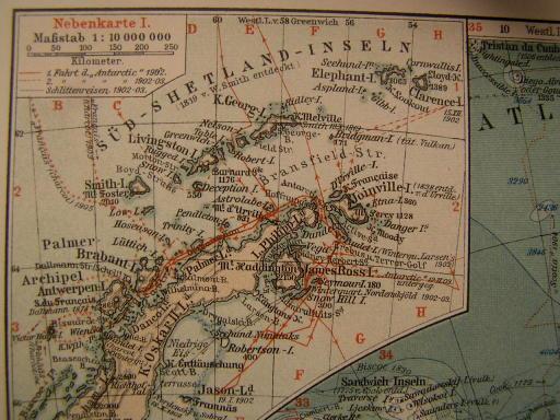
like there was a big sign over it, with an arrow saying “Cape Belsham Here”. I have found a map from 1912, a German Stieler map, of the Antarctic Peninsula. I attach it herein. While I make no pretense about this being the one that Worsley used, it does
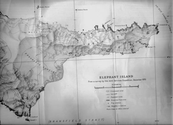
offer a suggestion. Elephant Island was not a highly explored location. Suppose for a moment, that the prominent Cape that Worsley selected was the one just to the south of Buskin Rocks on the later chart. That IS about 16 arc minutes away! If we accept
this theory, then all the reductions and chronometer error determinations make sense.
We all look at the modern charts and say, that’s Cape Belsham. Its labeled. Worsley looked at a pile of rocks under great adversity and (MAYBE) said, Cape
Belsham is that large prominent point down the coast, not this pile of little pile rocks.
Best Regards
Brad
From: NavList@navlist.net [mailto:NavList@navlist.net]
On Behalf Of hch
Sent: Tuesday, March 24, 2009 4:40 PM
To: NavList@navlist.net
Subject: [NavList 7755] Re: Transcription of Worsley's Log
|
Hi Brad, Perhaps we are working at cross purposes here, or misunderstand each other. I am not trying to correct Worsley's work, but rather have sought to simply explain the working of his sight for Longitude and his methodology of calculating his
CE therefrom, and thereby to demonstrate to the List in general how this was done historically. It was my understanding that both you and George were not factually aware of the actual position from which his observation was made and that the selection of Point Wild was an assumption, calculated or otherwise - if I am wrong then of
course Worsley appears to have made a mistake or we misunderstand the true meaning of his 1 min + 4 sec. DLo. I have simply played the part of the devil's advocate in, without his confirmation of the observation site, considering him to have been too good a navigator to have misstated the DLo between that site and his knowledge of the position
of Cape Belsham. I have tried to express the opinion, perhaps clumsily, to the effect that, without a factual knowledge of his observation site position and his knowledge of the position of Cape Belsham at the time, we are unable to assess the accuracy of
his work in the context of 1916. This in no way seeks to express an opinion with respect to the "what if" as respects the now known position of Cape Belsham and Point Wild or how this may have affected his subsequent movements. Perhaps time was of the essence, however, in like circumstances it perhaps may have been more appropriate to have waited a sufficient time to have confirmed the CE and position by additional observations over a longer period of time. Regards, Henry - On Tue, 3/24/09, bmorris@tactronics.com <bmorris@tactronics.com> wrote:
|
"Confidentiality and Privilege Notice
The information transmitted by this electronic mail (and any attachments) is being sent by or on behalf of Tactronics; it is intended for the exclusive use of the addressee named above and may constitute information that is privileged or confidential or otherwise legally exempt from disclosure. If you are not the addressee or an employee or agent responsible for delivering this message to same, you are not authorized to retain, read, copy or disseminate this electronic mail (or any attachments) or any part thereof. If you have received this electronic mail (and any attachments) in error, please call us immediately and send written confirmation that same has been deleted from your system. Thank you."
--~--~---------~--~----~------------~-------~--~----~
Navigation List archive: www.navlist.net
To post, email NavList@navlist.net
To , email NavList-@navlist.net
-~----------~----~----~----~------~----~------~--~---


