NavList:
A Community Devoted to the Preservation and Practice of Celestial Navigation and Other Methods of Traditional Wayfinding
Re: Fw: Grounding of cruiser PORT ROYAL
From: Frank Reed
Date: 2009 Jul 21, 23:04 -0700
From: Frank Reed
Date: 2009 Jul 21, 23:04 -0700
I'm attaching my solution for the position of the Port Royal on the reef. The
position is based primarily on composite2 which I posted in message 9144
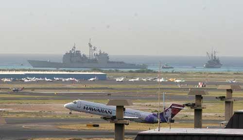
(www.navlist.net?i=109144). It is also based on a photo taken from
the airport. Originally, I didn't think the airport photos would be useful
since there are so few identifiable features but after some poking around, I
found one that showed some long buildings that I was able to identify in the
general aviation area of the fiel. I've attached that photo here. There is
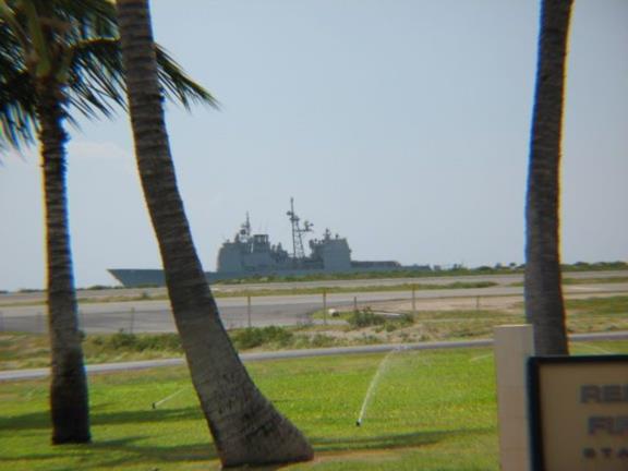
another at the airport with some palm trees in the immediate foreground that
suggested a location, but I wasn't sure until I figured out the second
airport photo.

Greg R. and I have been exchanging messages off-list about various
possibilities for the vantage point of the photo showing the Matson container
lot in the foreground. We were all over the place. Both of us independently
thought that it must have been taken from up in the hills well to the east of
downtown, but eventually after carefully checking small details in the
immediate foreground of the image (a USCG station apparently), I was able to
find the building and its approximate height, close to 300 feet above sea
level. This photo and the sunset photo, combined in the composites of the
earlier message, were taken from the same apartment building. The Sun was, as
expected, extremely useful since it provided an excellent angular scale.
Later, I found the "smoking gun" --the photos were taken by one professional
photographer, Marco Garcia, who perhaps lives in that building and has taken
at least one other shot looking northeast from the same rooftop.

The better photo from the airport has a very useful clue in addition to the
long buildings. The Hawaiian Airlines plane taking off in the foreground is a
Boeing 717 (Hawaiian does not fly any other aircraft in this family which
originally goes back to the DC-9). That aircraft is about 125 feet long while
the USS Port Royal is just about 4.5 times longer. In the photo, they have
the same apparent size. Therefore, necessarily, the photographer was 4.5
times farther away from the P.R. than the 717. After figuring out which
runway the aircraft is on/above and knowing already roughly where the P.R.
was located, it was a straight-forward matter to deduce this photographer's
location atop the parking garage to the north of the terminal. Those
structures in the near foreground that look like roof dormers confused me for
a long time. They appear to be quite close to the photographer, but it's an
illusion. They're on the terminal building about halfway between the
photographer's location and the 717.

All of the these photos are excellent examples of the compression of distance
in telephoto images. The vessel "appears" much closer to us than it actually
is.

My best position estimate for the tall radar mast on the P.R. is 21d 27' 50.0"
N, 157d 55' 24.3" W. The tip of the bow was about 2.5" east of there while
the stern was about 3.5" west of that point. The vessel was aligned nearly
east-west possibly headed a few degrees south of east.

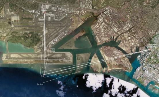
In the attached map named "final-chart" there are two sets of three lines
radiating from each photographer's location. The radiating lines extending
from north to south show the direction to the P.R. and the extreme left and
right edges of the image. The location of the Hawaiian Airlines 717 is also
shown. There is a single line showing the location of the palm trees for the
other airport photo (by the way, you can zoom right in on these and see the
trees quite clearly in Google Maps/Google Earth).

The second set of radiating lines starts at the apartment building in downtown
Honolulu. The center line, towards azimuth 256.4, passes through the center
of the P.R. while the other two are the limits of the daylight image section
in composite2. In the closest foreground of that image you can see a US Coast
Guard station with the bridge of a vessel just visible in the lower left.
That may be a buoy tender and it appears the same vessel is moored there in
the current images available on Google Maps. Behind it there's a "fixed"
trailer with two doors and steps leading up to them which is also clearly
visible in Google Maps (there's a helipad just in front of it). Behind that
is the Matson container lot. The long building has changed since the last
Google Map images. There are a number of large waste water treatment basins
beyond that (the most prominent was under construction when the last Google
Maps imagery was acquired --you can see the beginnings of its circular
outline there). The white "pipes" behind the basins and in front of a small
building are also clearly visible in the Google Maps imagery and in the
sunset portion of the composite. The vertical portion of the pipes is aligned
nicely with the center of the P.R. This alignment was critical to determining
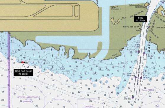
the vessel's position. Finally, just offshore you can see a buoy. This is
visible on the standard charts. It marks the east side of the "Kalihi
Channel". I've marked its approximate location on the image.

The last line indicates the approximate azimuth of the Sun in the sunset side
of the composite. Since the dip of the horizon from a 300 foot tall building
is just about 16 minutes of arc, the Sun would have been sitting right on the
horizon at that moment as seen from sea level. It appears that the sunset
photo was taken on February 7 (local date).

I'm also attaching a marked-up portion of the nautical chart for this area
(chart 19364, 1996). Notice the large number of navigational aids marking the
Kalihi Channel which would presumably have been plainly visible dead ahead
from the bridge of the Port Royal on the night they ran her up on the reef.

-FER
--~--~---------~--~----~------------~-------~--~----~
NavList message boards: www.navlist.net
Or post by email to: NavList@navlist.net
To , email NavList-@navlist.net
-~----------~----~----~----~------~----~------~--~---


