NavList:
A Community Devoted to the Preservation and Practice of Celestial Navigation and Other Methods of Traditional Wayfinding
From: Andrés Ruiz
Date: 2009 Sep 29, 09:41 +0200
Interesting
points of view about of subject.
Gary LaPook in [NavList 9968] is right, but
calculating the position at LAN has the taste of old times, when navigation was
more art and less science. Do you remember the film “master & commander”
taking shoots at noon aboard the HMS Surprise?.
George Huxtable, [NavList 9958], has put his finger
on the pulse, the problem is longitude, because the rate of change of GHA.
My opinion is the same as Joseph Schultz, [NavList
9964]. This fact is problem for the beginners when take a prestigious book as a
reference.
Recapitulating:
Avoid the EoT, BOWDITCH says: [NavList 9914]
“To calculate latitude and longitude at LAN,
the navigator seldom requires the time of meridian passage to accuracies greater
than one minute”
At time of LAN:
LHA = 0 for upper culmination and 180º for lower.
Then |L| = |GHA|
Sin H = sin Dec sin B +/- cos Dec cos B
Where B is the latitude
B = f( Dec, H )
L = f( GHA )
And with some simplifications the error e is function
of the rates of change of the variables:
eB = f( dDec/dt ) since at culmination dH/dt = 0 and is
near transit.
eL = f( dGHA/dt )
This is the academic point. Douglas Denny, [NavList
9939], compare practical navigation and theoretical astronomy.
For practical navigation, the question is: are you
near the coast or shallow waters? Is the error of 1 min acceptable? Are you in
blue water with no dangers around? Of course, the position obtained in such a
way is better than nothing.
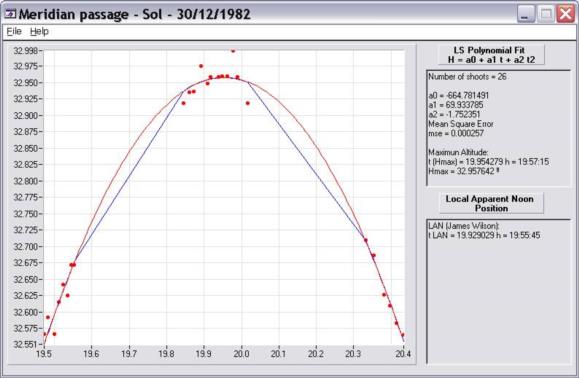
A numerical example: (Position from
observation of a single body. Jim N. Wilson)
30/12/1982 19:55:45
Sun
Number of shoots = 26
a0 = -664.781491
a1 = 69.933785
a2 = -1.752351
Mean Square Error
mse = 0.000257
Maximun Altitude:
t (Hmax) = 19.954279 h = 19:57:15
Hmax = 32.957642 º
LAN (James Wilson):
(full equation)
t LAN = 19.929029 h = 19:55:45
Dec = -23.149089 º
GHA = 118.285394 º
Checks:
LHA = 0.000000 º
Hc = 32.956525 º
Z = 180.000004 º
heye =
IC = 1.5
Latitude
Dec = -23.149088 = -23º 8.9'
Hs = 32.956525 = 32º 57.4'
Ho = 33.189697 = 33º 11.4'
Culmination = S
B LAN = 33.661215 = N33º 39.7'
Longitude
30/12/1982 19:55:45
GHA = 118.287461
L = W118.287461 = W118º
For other UT - Peter
Hakel has provided his solution: [NavList 9961]
30/12/1982 19:55:42
Dec = -23.149091 = -23º 8.9'
B = 33.661212 = 33º 39.7'
GHA = 118.274965
L = W118.274965 = W118º
30/12/1982 19:55:44
Dec = -23.149089 = -23º 8.9'
B = 33.661214 = 33º 39.7'
GHA = 118.283296
L = W118.283296 = W118º
Introducing an
error of 1 min:
30/12/1982 19:56:45
Dec = -23.149041 = -23º 8.9'
B = 33.661262 = 33º 39.7'
GHA = 118.537378
L = W118.537378 = W118º
In my humble opinion, 1 min of error in time of LAN
is unacceptable for longitude calculations, but is not a problem for latitude.
Andrés Ruiz
Navigational Algorithms
http://sites.google.com/site/navigationalalgorithms/
--~--~---------~--~----~------------~-------~--~----~
NavList message boards: www.navlist.net
Or post by email to: NavList@navlist.net
To , email NavList-@navlist.net
-~----------~----~----~----~------~----~------~--~---


