NavList:
A Community Devoted to the Preservation and Practice of Celestial Navigation and Other Methods of Traditional Wayfinding
From: George Brandenburg
Date: 2011 Jul 18, 15:32 -0700
Henry, thanks for the summary.
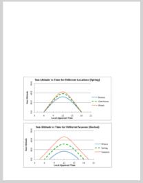
I think the attached two figures are very useful to explain solar sights to the uninitiated. They are taken from a Celestial Navigation Primer I put together a couple of years ago after taking Frank's Mystic Seaport course (it can be found at http://public.me.com/gwbburg). The figures are simple plots of the sun's altitude as a function of local apparent time, the first for three different latitudes and the second for three different seasons.
These figures clearly illustrate that a noontime sun sight is a good measure of latitude, once you correct for the seasonal variation (by adding the declination). And they also show that a morning or afternoon "time" sight is a good measure of local apparent time, provided that you already know your latitude and the time of year. Of course in order to find the local apparent time from this curve, you need to do our favorite spherical geometry calculation for your latitude and declination. But illustrations like this help people learn more than formulae do.
The other thing that is illustrated about time sights is that you need to be at least two hours away from solar noon so that the curve is steep enough for the altitude to give a good measure of the time. (But you also need to be an hour or so away from sunrise or sunset to avoid refraction.)
I too am sad we're not hearing from George H.
Cheers,
George B
----------------------------------------------------------------
NavList message boards and member settings: www.navlist.net/NavList
Members may optionally receive posts by email.
To cancel email delivery, send a message to NoMail[at]navlist.net
----------------------------------------------------------------


