NavList:
A Community Devoted to the Preservation and Practice of Celestial Navigation and Other Methods of Traditional Wayfinding
Re: (OFF-TOPIC) Flight 370
From: Gary LaPook
Date: 2014 Mar 26, 18:11 -0700
From: Gary LaPook
Date: 2014 Mar 26, 18:11 -0700
There is more information about the way the signals were analyzed here:
http://apps.washingtonpost.com/g/documents/world/images-from-britains-aaib-on-mh370/893/
http://apps.washingtonpost.com/g/documents/world/heres-an-analysis-of-satellite-data-from-britains-aaib/892/
http://www.washingtonpost.com/national/health-science/behind-the-data-on-missing-malaysian-jet-plenty-of-mystery-remains/2014/03/25/4f760d06-b43d-11e3-8cb6-284052554d74_story.html
gl
From: Frank Reed <FrankReed@HistoricalAtlas.com>
To: garylapook@pacbell.net
Sent: Wednesday, March 26, 2014 8:32 AM
Subject: [NavList] Re: (OFF-TOPIC) Flight 370
----------------------------------------------------------------
NavList message boards and member settings: www.navlist.net/NavList
Members may optionally receive posts by email.
To cancel email delivery, send a message to NoMail[at]navlist.net
----------------------------------------------------------------
http://apps.washingtonpost.com/g/documents/world/images-from-britains-aaib-on-mh370/893/
http://apps.washingtonpost.com/g/documents/world/heres-an-analysis-of-satellite-data-from-britains-aaib/892/
http://www.washingtonpost.com/national/health-science/behind-the-data-on-missing-malaysian-jet-plenty-of-mystery-remains/2014/03/25/4f760d06-b43d-11e3-8cb6-284052554d74_story.html
gl
From: Frank Reed <FrankReed@HistoricalAtlas.com>
To: garylapook@pacbell.net
Sent: Wednesday, March 26, 2014 8:32 AM
Subject: [NavList] Re: (OFF-TOPIC) Flight 370
Don Seltzer,
You wrote:
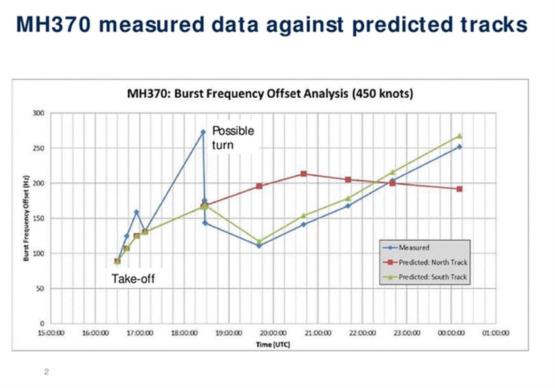
"I don't think that you can simply sum/difference the north/south speeds of the plane and the Inmarsat satellite. The Doppler shift is dependent on relative motion toward/away from each other. During the earlier portions of the flight after the last radar contact in the Straits of Malacca, flight 370 was almost due east of the satellite. Any N/S motion of either body would be nearly tangential to the 'circle of distance rings', creating very little instantaneous difference in distance. Only later in the flight, when the plane was possibly to the SW or NE, would this effect be noticeable."
"I don't think that you can simply sum/difference the north/south speeds of the plane and the Inmarsat satellite. The Doppler shift is dependent on relative motion toward/away from each other. During the earlier portions of the flight after the last radar contact in the Straits of Malacca, flight 370 was almost due east of the satellite. Any N/S motion of either body would be nearly tangential to the 'circle of distance rings', creating very little instantaneous difference in distance. Only later in the flight, when the plane was possibly to the SW or NE, would this effect be noticeable."
Gee whiz, Don, do you really think that I don't understand the Doppler effect?!? Of course this analysis would not work near the beginning of the flight, but we're not really interested in the details of the plane's location near the beginning of the flight, are we? "Later in the flight" is the only part that matters right now. The Doppler shift MAY have been critical towards understanding the last couple of hours of the flight, but you're right that it would not have helped when the plane was near the Straits of Malacca.
And you also wrote:
"They may have been looking for a course which intersected the half dozen circle of distance rings at the correct times, and exhibited Doppler shifts of the correct magnitude for the delta to the next ring. "
"They may have been looking for a course which intersected the half dozen circle of distance rings at the correct times, and exhibited Doppler shifts of the correct magnitude for the delta to the next ring. "
Yes. But, possibly (given the very small amount of information available) a key factor here is that the Doppler shifts would have been significantly different north to south because of the satellite's relative speed. A north-south speed of 100-175mph for the satellite (and changing during the long flight) is a substantial difference.
-FER
----------------------------------------------------------------
NavList message boards and member settings: www.navlist.net/NavList
Members may optionally receive posts by email.
To cancel email delivery, send a message to NoMail[at]navlist.net
----------------------------------------------------------------
: https://navlist.net/m2.aspx?i=127378


