NavList:
A Community Devoted to the Preservation and Practice of Celestial Navigation and Other Methods of Traditional Wayfinding
From: Murray Buckman
Date: 2024 Feb 7, 19:34 -0800
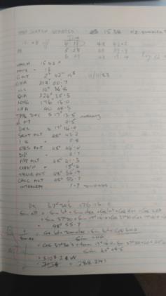
OK - here is a bit of fun. The attached image is a page from one of my logs. The date (GMT) is 11/11/83: Armistice Day (or alternate names depending on where you live). This is a sun sight, and the last sight on this particular trip. The sight itself was not really necessary. The boat was a handful of miles off a low coast but with a prominent hill visible. A line from that hill gave a fix. We knew where we were going. But hey, the sun was out, the crew was keen, and the beer was cold.
Some points to note.
- All workings are in pencil - a strong personal preference.
- No sight reduction form is used. At this point in my celnav life it was all memorized and scribbled down on the same sheet as the sextant observations (in dry weather). Essentially this is what I called a deck log.
- A simple non-programmable scientific calculator was used (Casio FX-82 if I recall - first model). I always carried the Air Tables as backup.
- GMT was still GMT.
- I never was very good at keeping my numbers in column.
- E, W, N,S was rarely used. We knew where we were, and yet I have annoted the DR position with S and E. I guess I was being fussy that day.
- I had a crew member write down the times and sextant readings - note the different handwriting.
- Note the little diagram at the bottom left of the page. Silly and unnecesary? Perhaps - but a habit and one that preventted silly errors.
- The result would have been plotted onto a UPS, but at this stage of the voyage, probably not marked on the chart. I always took my own charts (so they were current and marked up with applicable NTM). But I tried to minimize unnecesary markings which shortended their life (the cost money). This was especially true at the end of voyages where lines converge on a destination.
Feel free to critique the workings. There are things I would do differently and did do differently in different circumstances. Have at it.
From the information on the page, you can also guess how (roughly) big a boat I was on. Is it an aircraft carrier, or a kayak?
Anyway - this is a genuine page from a genuine logbook, from a vessel that did not have electronic navigation aids aboard.
Murray


