NavList:
A Community Devoted to the Preservation and Practice of Celestial Navigation and Other Methods of Traditional Wayfinding
From: Rafael C. Caruso
Date: 2023 Apr 12, 09:32 -0700
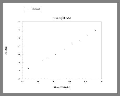
When taking sun sights from the shore, I have adopted a method which helps me to reduce my chances of obtaining an incorrect altitude measurement. A series of sights, --obtained two to three minutes apart, allows detecting and eliminating an incorrect outlier value. I first saw this approach illustrated in Hewittt Schlereth’s book “Commonsense celestial navigation”, though I assume it has been described earlier and later.
The graph attached shows a set of sun sights taken from the boardwalk in Belmar, New Jersey (40°10’N, 74°01’W) on August 10, 2020, between 9:30 a.m. and 10:00 a.m. US Eastern daylight saving time (13:30 to 14:00 UT). These are just “raw” sextant altitude values (Hs). In this example, it is easy to fit these data points with a straight line, reduce them to a single Hs value, and then correct this value to obtain a single observed attitude Ho. As I was stationary while taking these sights, I haven't used a correction for observer motion.
My question is the following: during this 25 minute interval, the sun was not only changing its altitude, but also its azimuth and geographical position. Should this be taken into consideration to adjust the data points before fitting them with a straight line? Or is this interval short enough to make this unnecessary? Many thanks in advance for your advice and comments.
Best regards, RafaelC


