NavList:
A Community Devoted to the Preservation and Practice of Celestial Navigation and Other Methods of Traditional Wayfinding
From: Greg Rudzinski
Date: 2017 Feb 2, 08:18 -0800
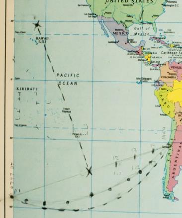
The approximate great circle plot works ok. Not perfect but does serve to shorten the trip vs. the rhumbline. See attached plot done on a Webster's compact world atlas chart using Nicholl's method as dotted line vs. computed GC as dashed line.
Useful pilot chart which shows a GC route between Auckland and Valparaiso :
https://matdanweather.com/img/pc/07/SP07_2.jpg
Greg Rudzinski
From: David C
Date: 2017 Feb 1, 23:52 -0800A pocket atlas just might be good enough to get you home. A pencil width is about 5' nm.
Greg Rudzinski
NZers on this forum will remember the red covered NZ School Atlas. My copy is packed away and I could not find it. The only atlas I have to hand is a slightly too large for the scanner so in the following example the map image is a little out of focus.
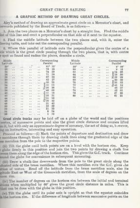
I want to follow the orthodrome to SCL. After some hunting around I came across a graphical method of plotting a great circle. It was devised by Airy. The method is very easy although I did not have a large enough compass so used the waist tie of an apron to draw the GC.
I have attached two files.
- A page from Nicholls's Concise Guide which drew my attention to the method.
- A cut from a 1921 atlas showing the GC between Auckland and Santiago.
A paper describing Airy's method is https://cartography-gis.com/docsbca/iccgis2016/ICCGIS2016-34.pdf The paper contains the comment Constructing a corresponding arc of circle would require a large enough compass and a map in a small scale.
Attached File:


