NavList:
A Community Devoted to the Preservation and Practice of Celestial Navigation and Other Methods of Traditional Wayfinding
From: Brad Morris
Date: 2016 Feb 2, 18:45 -0500
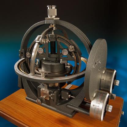
The article states that the price was 30,000 marks just when GPS took over. Call that 1973. The exchange rate was 3.2 DM/$1 in 1973, yielding 9375USD. Account for inflation, and this device should sell for over $58,000 today.
The claim of 1' without electrons is impressive, yet my high end programmable electronic calculator in 1975 was ~$400, including the printer. Roughly 1/20th the price and the calculation was accurate to several decimal places, far exceeding the claimed device accuracy.
I would like to understand how this device functions!
Brad
Now here is an interesting navigation slide rule - and 3D too... The Astra-Plot a "three dimensional slide-rule" for celestial navigation, 1969
According to the writeup:
Five specific data to specify the location of a ship
The device specifies the location of a ship to within one nautical mile without the need of any paper calculations. Five specific data are required: First, the approximate position of the ship as determined by the compass bearing and travel time; second, the height of a star above the horizon, preferably the sun, as measured by a sextant; third, the exact compass direction of that star as determined by an amplitude compass; fourth, its hour angle as determined by the time of day and a nautical chart and, fifth, the angular distance of the star to the celestial equator as determined by the nautical chart or the star map.
http://www.sdtb.de/January.2290.0.htmlEd Popko
Attached File:
(415_415_astra-plot_20131125-.jpg: Open and save)


