NavList:
A Community Devoted to the Preservation and Practice of Celestial Navigation and Other Methods of Traditional Wayfinding
Re: Historical Tide Data
From: Lu Abel
Date: 2015 Apr 16, 20:26 +0000
From: Lu Abel
Date: 2015 Apr 16, 20:26 +0000
Frank:
What's the URL for these NOAA data? Would love to review US West Coast data.
What's the URL for these NOAA data? Would love to review US West Coast data.
From: Frank Reed <NoReply_FrankReed@navlist.net>
To: luabel@ymail.com
Sent: Thursday, April 16, 2015 12:41 PM
Subject: [NavList] Re: Historical Tide Data
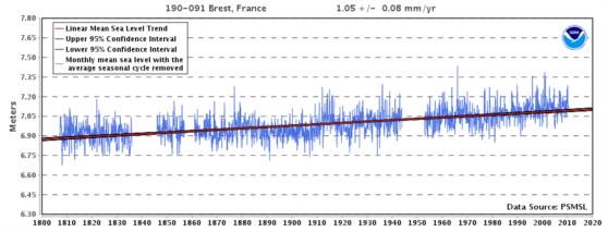
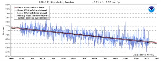
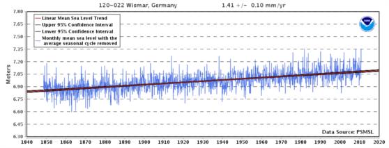
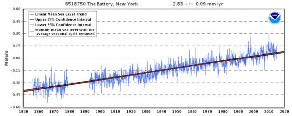
Antoine,Yes, the same NOAA sea level trend site also has graphs for many global (non-US) locations including Brest. Below (attached) is the sea level trend for Brest from about 1807 to about 2010. By the way, these data reflect "relative sea level" rather than global sea level, which explains why sea level at Brest is rising more slowly than in New York. I'm also attaching graphics for Stockholm, Sweden (where relative sea level is falling as that region conntinues its re-emergence from the weight of the ice cap of the last glaciation) and also for Wismar, Germany which has a long data set, though not as long as Brest, which I believe is the global record-holder.
Attached File:
(sea-level-brest-france.png: Open and save)
Attached File:
(sea-level-stockholm-swe.png: Open and save)
Attached File:
(sea-level-wismar-germany.png: Open and save)
Attached File:
(f1-sea-level-trend-nyc.png: Open and save)


