NavList:
A Community Devoted to the Preservation and Practice of Celestial Navigation and Other Methods of Traditional Wayfinding
From: Antoine Couëtte
Date: 2024 Feb 28, 09:43 -0800
Dear Matus,
Congratulations ! From the Steeple you are finding 237° / 4.10 km, and ...
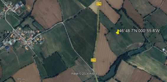
with the very same approach as yours, I am deriving 238° / 4.20 km from the steeple, yielding an Photograph's position at 46°48.7'N 000°55.8'W with a picture taken at 16:47 UT too.
According to M. Google Map, with the Steeple ground altitude at 275 m and the spot hereabove altitude at 125 m, there is a 150 m altitude change over 4.200 m, which makes an uphill slope angle at 02°02' , while at 16:47 UT the Moon LL altitude is at 02°01.2' in Azimuth 057.6°. There is not much we could do better.
[see attached image]
As we both can compare, our positions are within 100 y of one another.
I did not go this time for an error rectangle while my result is inside your error rectangle.
So, here we are, and yes, I surmise that the picture might have taken from the nearby road, very close from the position where your most western rectangle corner intersects it.
I am very happy at your contribution. Congratulations again.
Hopefully within 2 weeks I will be able to drive there and publish a few pictures on NavList.
Best Regards,
Kermit
PS : Very soon one other Moon related puzzle from a worldwide renown picture ...


