NavList:
A Community Devoted to the Preservation and Practice of Celestial Navigation and Other Methods of Traditional Wayfinding
Re: Mercator Sailing and Meridional Parts
From: Gary LaPook
Date: 2014 Dec 4, 00:10 -0800
From: Joel Silverberg <NoReply_Silverberg@navlist.net>
To: garylapook@pacbell.net
Sent: Tuesday, December 2, 2014 2:56 PM
Subject: [NavList] Re: Mercator Sailing and Meridional Parts
Attached File:

(f1-meridionalPartsDerivation.pdf: Open and save or View online)
From: Gary LaPook
Date: 2014 Dec 4, 00:10 -0800
I have attached Edwards Wright's table of meridional parts published in his 1599 book, it is the very first such table. Compare it with the table in Bowditch and you will see he got it quite right.
gl
From: Joel Silverberg <NoReply_Silverberg@navlist.net>
To: garylapook@pacbell.net
Sent: Tuesday, December 2, 2014 2:56 PM
Subject: [NavList] Re: Mercator Sailing and Meridional Parts
There seems to be a lot of confusion on the list about how Meridional Parts are calculated and what they mean.
Meridional parts were designed to correct for the distortions introduced in a Mercator projection, so that sailing a course
of constant directional bearing appears as a straight line on the chart.
The Mercator chart presents any course of constant direction as a straight line in (when in fact such courses trace spirals on the surface of the sphere, unless the course lies along a meridian or a parallel of latitude).
The change in latitude of such a course does correspond net "northing" of 60 nautical miles per degree of latitude change. But the change in longitude does not correspond to a simple change in "easting" since the conversion factor
constantly alters with every change in latitude. Converting a change in longitude to the number of nautical miles traveled in an eastward or westward direction requires correcting for the stretching of E/W distances by a factor which varies with the cosine or the secant of the latitude.
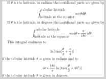
Mathematically this is done by integrating the secant of the latitude along the course. The numbers in the table of Meridional Parts show the sum of the distortions starting from the equator and proceeding along the a Northward course until the final latitude is reached.
A consequence of the Fundamental Theorem of the Calculus is that the distortions along any path can be found by subtracting the values of the antiderivatives at the starting point and
ending point. Thus to find the correction needed to correct from a path that starts at one latitude and concludes at another, one need only look up the value in the table at the final latitude
and
substract the value in the talbe at the initial latitude.
The earliest Meridional tables (Edward Wright, ca. 1600) predate the invention of the calculus and integration and were generated by finding the distortion along each portion of the course resulting
in a one second of arc change in latitude and adding such changes together. It was eventually discovered (Henry Bond, ca. 1640) and then proved (James Gregory , Isaac Barrow, ca 1670) that this value was equal to the natural logarithm of the tangent of the sum of
half the final latitude and 45 degrees, adjusted for the appropriate angular units (degrees, rather than radians) and converted to nautical miles (i.e. seconds of arc).
The entries in tables of Meridional Parts can be reproduced by calculating (180/Pi degrees per radian) x (60 nautical miles per degree) x Ln ( tan ( (final latitude/2) + 45 degrees) ).
This pdf file attached to this message will show the mathematical derivation more clearly than I can do in a text-based message.
Those interested in further details might read : http://facultypages.morris.umn.edu/~catkinso/2014/fall/1102/integral-of-secant.pdf
An Application of Geography to Mathematics: History of the Integral of the Secant Author(s): V. Frederick Rickey and Philip M. Tuchinsky
Source: Mathematics Magazine, Vol. 53, No. 3 (May, 1980), pp. 162-166
Published by: Mathematical Association of America Stable URL: http://www.jstor.org/stable/2690106 . Accessed: 05/05/2014 12:18
Source: Mathematics Magazine, Vol. 53, No. 3 (May, 1980), pp. 162-166
Published by: Mathematical Association of America Stable URL: http://www.jstor.org/stable/2690106 . Accessed: 05/05/2014 12:18
or
https://www.academia.edu/5871968/The_Sailings_The_Mathematics_of_Eighteenth_Century_Navigation_in_the_American_Colonies
There is a downloadable paper on the use of meridional parts at the link above.
Proceedings of the Canadian Society for History and Philosophy of Mathematics, Volume 18, pp 173 - 199
Attached File:

(f1-meridionalPartsDerivation.pdf: Open and save or View online)


