Welcome to the NavList Message Boards.

NavList:

A Community Devoted to the Preservation and Practice of Celestial Navigation and Other Methods of Traditional Wayfinding

Compose Your Message

Message:αβγ
Message:abc
Add Images & Files
    Name or NavList Code:
    Email:
       
    Reply
    Plotting vs calculating Position
    From: Ron Jones
    Date: 2015 Jul 29, 11:33 -0700

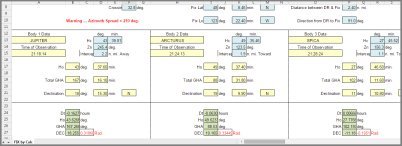
    When usng the Universal Plotting Sheet (UPS) to determing position from the intercepts & azimuths of 2 or 3 body celestial observations, the width of the lines plotted on the UPS representing the LOPs can approach or exceed 1 nautical mile.  The method described in Paragraph 11 "Positin from intercept and azimuth by calculation" on page 282 of the Nautical Almanac can be used to calculate an accurate position. This method can easily be programmed into a TI Voyage 200 calculator or implemented as an Excel spread sheet (see attached Excel worksheet)


    File:


    Reply
    Browse Files

    Drop Files

    NavList

    What is NavList?

    Get a NavList ID Code

    Name:
    (please, no nicknames or handles)
    Email:
    Do you want to receive all group messages by email?
    Yes No

    A NavList ID Code guarantees your identity in NavList posts and allows faster posting of messages.

    Retrieve a NavList ID Code

    Enter the email address associated with your NavList messages. Your NavList code will be emailed to you immediately.
    Email:

    Email Settings

    NavList ID Code:

    Custom Index

    Subject:
    Author:
    Start date: (yyyymm dd)
    End date: (yyyymm dd)

    Visit this site
    Visit this site
    Visit this site
    Visit this site
    Visit this site
    Visit this site