NavList:
A Community Devoted to the Preservation and Practice of Celestial Navigation and Other Methods of Traditional Wayfinding
From: Antoine Couëtte
Date: 2024 Jun 6, 07:05 -0700
Hello again to all, (third time is charm)
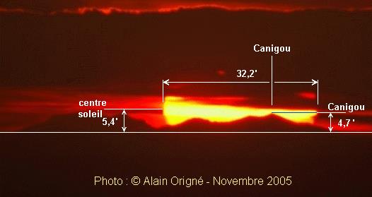
The attached picture depicts a spectacular Sunset seen from a distance exceeding 140 NM as indicated in this most recent attachment which actually "solves" for the amazing - nonetheless realistic - vertical angular position of Pic du Canigou seen from Allauch over the maritime refracted horizon.
But, Pic du Canigou is not alone in the enclosed picture, let's take a look at Mr Sun !
*******
Solving this puzzle involves a simple question :
Assuming that you do observe the Sun Center setting at 5.4' above the [maritime refracted] horizon, what is your intercept ?
*******
To make this less difficult, here are the crunched and ready to use environmental data:
Date, Time, Observer's Position :
Nov 1st, 2025 , UT = 16h30m47.6s , Observer's Position : N43°20'12" / E005°29'10" , AMSL 310 m , Above WGS84 : +360 m
Sun Azimuth at 250.75° and Sun observed at 5.4' over the local maritime refracted horizon.
To be comprehensive, here are the Sun Data for the exact time of the Observation (which should adequately match FER's Nautical Almanac Computer ones, which I have not checked actually) : GHA = 71°48.1' Dec = -14°36.6' Distance 0.992376, which makes the Sun horizontal parallax extremely close from 0.15' . No need from any other astronomical data since we - again - deal with the Sun Center.
What is the infrequent situation encountered here ?
Any method to solve it through Classical [tabular, no calculator/computer] Methods, excluding software ? (This is why I am referring to Nautical Almanac data here) .
Enjoy,
Kermit


