
NavList:
A Community Devoted to the Preservation and Practice of Celestial Navigation and Other Methods of Traditional Wayfinding


From: Antoine Couëtte
Date: 2025 Oct 18, 07:48 -0700
Dear David,
Interesting indeed this result of yours.
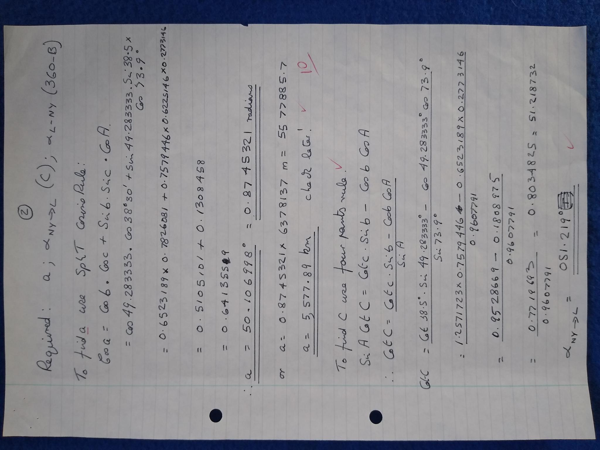
We both end up with the very same geocentric angular distance between London and New York at 0.874 532 102 radian, from which we derive different values in kilometers:
- You got 5,577.89 km through using the WGS84 Great Axis (6,378.147 km) as a radius of "your" sphere.
- I have been using a significantly different (and more traditionnal ?) sphere with our 1,852 m well known value for NM and I got 5,567.89 km
*******
On an historical standpoint, the Meter was defined (by the French) as the 1/10,000 value of a Meridian from Equator to Pole. While it was easier then to keep considering the Earth as a sphere, its Equator length was assumed by definition to be equal to 40,000 km. Hence an early value of 40,000 km / (360 * 60) = 1,851.851 851 m rounded up to 1,852 m (by the British I think) was derived for the Nautical Mile lenght. So far, so good ...
WGS 84 clocks at 10,001. 966 Km from equator to Pole - hence a "North/South flattened circumference" of 40,007.863 km - yielding an "improved" value of 10,001.966 km /(5400) = 1,852.215 93 km for the NM. No need to change the previous NM definition then which has kept its earlier 1,852 m value unchanged, and even closer to 1/10,000 of the WGS 84 Equator to Pole Meridian distance.
*******
Food for thought
For distances in km to be derived fom GC computed on a sphere, which sphere radius should we then consider ?
- The WGS 84 Meridian radius corresponding to a "North/South Flattened Circumference" of 40,007.863 km ? Or rather :
- Just 40,000 km as I was earlier trained ? (Still good enough for Government purposes ?) . Or from now on:
- The Sphere having the same radius as WGS 84, which you have been using, David, yielding 6,378.137 * 0.874 532 102 = 5,577.885 557 km exactly matching you own result at 5,577.88 km ?
Quite misleading occurrence here, since between our respective first 6 leading digits there is an incredible difference of exactly ... 0010.00 km (5,577.88 km vs. 5,567.88 km) !!! I suspected a typo in your published result.
Certainly M.Vincenty's method remains our reference here (at 5,586.660 846 km). But its iterative computations are complex, arent' they ?
In any case in this specific example your own result, David, is significantly closer to Vincenty's result.
Nonetheless is the 40.000 km spherical circumference I was trained to use in the French Navy [in the last millenium I have to confess ...] still the [worlwide] official rule for Navigators at Sea ?
I am just curious to know here ... just in case my first - and only - extra-terrestrial navigation from Earth to Heavens might give routing instructions in Nautical Miles instead of Kilometers. I certainly do not want to end up in the wrong harbour.
Anybody to comment here on the actual spherical radius to be used ?
Kermit


