NavList:
A Community Devoted to the Preservation and Practice of Celestial Navigation and Other Methods of Traditional Wayfinding
From: Antoine Couëtte
Date: 2024 Apr 4, 11:16 -0700
Dear Geoff and dear all,
Last but not least : further to the kind contributions - thanks again to you - by Frank E. Reed and Paul Hirose, on the subjects of both "terrestrial refraction" and "WGS84 Altitudes" completed by my last findings on WGS84 altitudes, I have been able to finalize this time my own solution through fine-tuning my previously published [provisional] result.
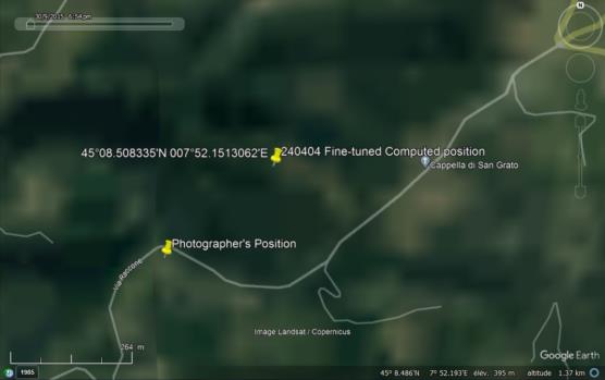
Final computed position is showing up in the enclosure altogether with the Photographer's position indicated to me by the Author of this awesome picture .
Both positions are less than 0.15 NM apart.
For those interested by some of the "tricks" I used here :
(1) - First of all, I devoted a lot of efforts into deriving the Observer's Distance to the Superga steeple since distance here is generally the variable with the biggest uncertainty. I simply very carefully averaged the vertical and horizontal angular sizes of various parts of the Superga Basilica in order to derive an initial distance of 5.75 NM (10,649 m) between the Photographer and the steeple.
(2) - I then carefully computed the azimuth from Superga to MonViso, which actually is extremely close from the geodetic curve initial course angle used by Geoff Hitchcox. Although the departing azimuth on an Elllipsoid is not the same mathematical object as the initial course of a geodetic curve, both "objects" are so close that I need to take back this earlier comment :" both differ by about to +/- 0.15°in this specific case. " Actually, from Superga to Monviso - and at zero altitude on the WGS84 Ellipsoid - the actual Azimuth is 229.6160238° and the geodesic curve initial departure course is 229.6160214° : such difference in this specific example is under 0.01", close to the "computation noise" of the calculator. But both "objects" are mathematically different since in particular the geodetic curve on the Ellipsoid is a "skewed" or "non-planar" curve, or in other words it cannot be "entirely contained" in a plan.
(3) - From Superga I then computed the position of a point in reciprocal course at 049.6160238° and at a distance of 5.75 NM and happened to "land" in a quite steep terrain.
(4) - It prompted me into computing for different points of the "MonViso - Superga" extended line the actual observed refraction of both the Superga steeple and MonViso, with of course both refraction errors to be positive and realistic. Here I used T=+5°C and QFE = 930 hPa.
I stopped my reseach onto the published end-result with the MonViso Refraction at 3.7' and the Superga steeple refraction at 1.4' at a point which is at 10,480 m from Superga. Certainly the Superga refraction is too big in comparison of the MonViso refraction, but only 10 meters closer to Superga - i.e. at 10,470 m from Superga - the Steeple refraction is just at 0.0' because of the steep slope. Hence there was no sense to further refine the computed position which - as expected - lies exactly (to better than one meter right or left) on the actual extended certerline between Superga and the Photographer's true position.
This concludes - for me at least - this lenghty post with again my warmest thanks to Geoff, Frank and Paul.
And again, warmest congratulations from all of us to you M. Valerio Minato.
Kermit


